IMAGES TAKEN NEAR TO
Hood Road, SCUNTHORPE, DN17 1RZ
Introduction
This page details the photographs taken nearby to Hood Road, DN17 1RZ by members of the Geograph project.
The Geograph project started in 2005 with the aim of publishing, organising and preserving representative images for every square kilometre of Great Britain, Ireland and the Isle of Man.

There are currently over 7.5m images from over14,400 individuals and you can help contribute to the project by visiting https://www.geograph.org.uk
Image Map
Images are licensed for reuse under creativecommons.org/licenses/by-sa/2.0
Notes
- Clicking on the map will re-center to the selected point.
- The higher the marker number, the further away the image location is from the centre of the postcode.
Image Listing (8 Images Found)
Images are licensed for reuse under creativecommons.org/licenses/by-sa/2.0
Image
Details
Distance
2
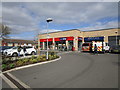
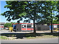
The Arc, Westcliffe, Scunthorpe
Community hub and cafe.
Image: © Jonathan Thacker
Taken: 10 Apr 2019
0.14 miles
5
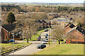
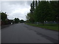
Bridges Road
Bridges Road from the bridge on The Ridgeway cycle route
Image: © Richard Croft
Taken: 15 Mar 2021
0.22 miles
6
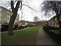
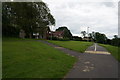
Westcliffe Estate
Much of the planning of the Westcliffe estate is in accordance with Radburn principles http://en.wikipedia.org/wiki/Radburn,_New_Jersey Here the cul-de-sacs of Coventry Close (left) and Canterbury Close (right) are separated by green pedestrianised areas.
Image: © Jonathan Thacker
Taken: 27 Feb 2012
0.22 miles
7
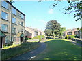
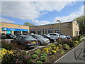
Social housing, South Scunthorpe
1960's estates between Westcliff and the Scotter Road.
Image: © Jonathan Billinger
Taken: 28 May 2010
0.24 miles