IMAGES TAKEN NEAR TO
Herrick Road, SCUNTHORPE, DN17 1NW
Introduction
This page details the photographs taken nearby to Herrick Road, DN17 1NW by members of the Geograph project.
The Geograph project started in 2005 with the aim of publishing, organising and preserving representative images for every square kilometre of Great Britain, Ireland and the Isle of Man.

There are currently over 7.5m images from over14,400 individuals and you can help contribute to the project by visiting https://www.geograph.org.uk
Image Map (Loading...)


Getting Data...Please wait
Leaflet Map data © OpenStreetMap
Images are licensed for reuse under creativecommons.org/licenses/by-sa/2.0
Notes
- Clicking on the map will re-center to the selected point.
- The higher the marker number, the further away the image location is from the centre of the postcode.
Image Listing (47 Images Found)
Images are licensed for reuse under creativecommons.org/licenses/by-sa/2.0
Image
Details
Distance
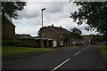
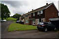
3
Bridges Road
Bridges Road from the bridge on The Ridgeway cycle route
Image: © Richard Croft
Taken: 15 Mar 2021
0.08 miles
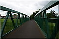
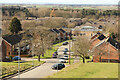
6
Foot and cycle bridge over Bridges Road
Bridge spanning Bridges Road, opened 2011.
The bridge is one of two footbridges which form a crucial part of the Ridgeway, a traffic-free path which runs north-south through green space for 10 km the length of Scunthorpe. Construction of the path is the realisation of a dream of Sir Patrick Abercombie (1879-1957), the famous planner who once worked in town planning in Scunthorpe.
It is not known where the name "Bridges Road" derives from, but it predates the construction of this bridge by some years.
Image: © Oliver Dixon
Taken: 10 Mar 2014
0.10 miles
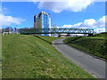
7
Bridges Road gets a bridge
The new bridge over Bridges Road carries a cycle path which runs the length of the escarpment in Scunthorpe.
Image: © Jonathan Thacker
Taken: 22 Dec 2011
0.10 miles
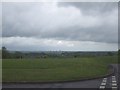
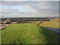
8
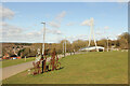
The Ridgeway, NCN Route 169
The Ridgeway, portrait bench and West Common Lane bridge
Image: © Richard Croft
Taken: 15 Mar 2021
0.10 miles
9
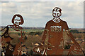
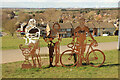
Ridgeway Portrait Bench, Route 169
Detail of the portrait bench sculpture http://www.geograph.org.uk/photo/6781551
Image: © Richard Croft
Taken: 15 Mar 2021
0.10 miles