IMAGES TAKEN NEAR TO
Lancaster Road, SCUNTHORPE, DN16 3XT
Introduction
This page details the photographs taken nearby to Lancaster Road, DN16 3XT by members of the Geograph project.
The Geograph project started in 2005 with the aim of publishing, organising and preserving representative images for every square kilometre of Great Britain, Ireland and the Isle of Man.

There are currently over 7.5m images from over14,400 individuals and you can help contribute to the project by visiting https://www.geograph.org.uk
Image Map (Loading...)


Getting Data...Please wait
Leaflet Map data © OpenStreetMap
Images are licensed for reuse under creativecommons.org/licenses/by-sa/2.0
Notes
- Clicking on the map will re-center to the selected point.
- The higher the marker number, the further away the image location is from the centre of the postcode.
Image Listing (18 Images Found)
Images are licensed for reuse under creativecommons.org/licenses/by-sa/2.0
Image
Details
Distance
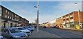
1
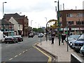
Ashby Broadway
Facing East, the Crown Public House is on the right and in the distance the Steelworks
Image: © Steve Parker
Taken: 20 May 2005
0.18 miles
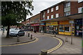
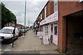
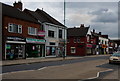
3
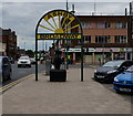
Ashby Broadway
The folks of North Lincolnshire know how to give their shopping streets a catchy name!
Image: © Jonathan Billinger
Taken: 27 May 2010
0.20 miles
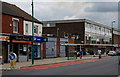
9
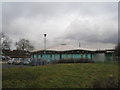
Ashby Education Preparation Unit
Supports children aged three to five who have behavioural or educational difficulties.
Image: © Jonathan Thacker
Taken: 25 Jan 2011
0.22 miles