IMAGES TAKEN NEAR TO
Lapwing Way, SCUNTHORPE, DN16 3WN
Introduction
This page details the photographs taken nearby to Lapwing Way, DN16 3WN by members of the Geograph project.
The Geograph project started in 2005 with the aim of publishing, organising and preserving representative images for every square kilometre of Great Britain, Ireland and the Isle of Man.

There are currently over 7.5m images from over14,400 individuals and you can help contribute to the project by visiting https://www.geograph.org.uk
Image Map (Loading...)


Getting Data...Please wait
Leaflet Map data © OpenStreetMap
Images are licensed for reuse under creativecommons.org/licenses/by-sa/2.0
Notes
- Clicking on the map will re-center to the selected point.
- The higher the marker number, the further away the image location is from the centre of the postcode.
Image Listing (45 Images Found)
Images are licensed for reuse under creativecommons.org/licenses/by-sa/2.0
Image
Details
Distance
1
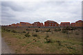
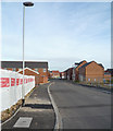
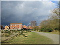
Houses on lapwing Way, Ashby
Taken from the Opencast Way.
Image: © Ian S
Taken: 21 Mar 2016
0.03 miles
3
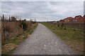
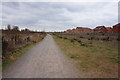
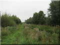
Path towards Whimbrel Chase
A footpath from Ashbyville Nature Reserve.
Image: © Oscar Taylor
Taken: 21 Jul 2023
0.04 miles
5
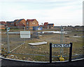
Stalled Development, Heron Gate, Brat Hill
Work on this part of the Lakeside development appears to have stalled, presumably due to the current adverse economic conditions.
Image: © David Wright
Taken: 20 Nov 2008
0.06 miles
6
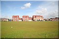
New homes at Lakeside
New homes on the Lakeside development
Image: © Richard Croft
Taken: 2 Sep 2008
0.08 miles
8
New Street on the Lakeside Development
When this picture was taken building work on this part of the development appeared to have ceased due to the current adverse economic conditions.
Image: © David Wright
Taken: 20 Nov 2008
0.10 miles
9
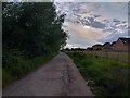
Footpath on the edge of Ashbyville Local Nature Reserve
The Ashbyville Local Nature Reserve has been created around a former ironstone quarry.
Image: © Jonathan Thacker
Taken: 1 Mar 2017
0.10 miles
10
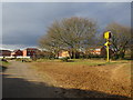
Very real warning
The yellow sign says "Warning Danger of Drowning". It may seem excessively large but sadly Ashbyville Lake has seen several drownings and people moving into new housing nearby need to be made aware of the very real danger that the former open cast quarry, that is now Ashbyville Lake, poses.
Image: © Jonathan Thacker
Taken: 1 Mar 2017
0.12 miles