IMAGES TAKEN NEAR TO
Grange Lane South, SCUNTHORPE, DN16 3BH
Introduction
This page details the photographs taken nearby to Grange Lane South, DN16 3BH by members of the Geograph project.
The Geograph project started in 2005 with the aim of publishing, organising and preserving representative images for every square kilometre of Great Britain, Ireland and the Isle of Man.

There are currently over 7.5m images from over14,400 individuals and you can help contribute to the project by visiting https://www.geograph.org.uk
Image Map (Loading...)


Getting Data...Please wait
Leaflet Map data © OpenStreetMap
Images are licensed for reuse under creativecommons.org/licenses/by-sa/2.0
Notes
- Clicking on the map will re-center to the selected point.
- The higher the marker number, the further away the image location is from the centre of the postcode.
Image Listing (16 Images Found)
Images are licensed for reuse under creativecommons.org/licenses/by-sa/2.0
Image
Details
Distance
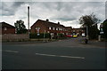
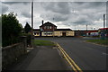
8
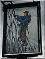
The Sherpa public house
A Sam Smith's pub on Grange Lane South, Ashby, Scunthorpe.
Image: © Ian S
Taken: 11 Jun 2014
0.20 miles
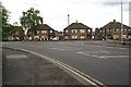
9
The Sherpa public house
This Sam Smith's pub is on Grange Lane South but the photograph was taken from Everest Road, Ashby, Scunthorpe.
Image: © Ian S
Taken: 11 Jun 2014
0.20 miles
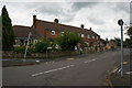
10
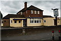
The Sherpa public house
A Sam Smith's pub on Grange Lane South, Ashby, Scunthorpe.
Image: © Ian S
Taken: 11 Jun 2014
0.20 miles