IMAGES TAKEN NEAR TO
Lime Grove, SCUNTHORPE, DN16 2HL
Introduction
This page details the photographs taken nearby to Lime Grove, DN16 2HL by members of the Geograph project.
The Geograph project started in 2005 with the aim of publishing, organising and preserving representative images for every square kilometre of Great Britain, Ireland and the Isle of Man.

There are currently over 7.5m images from over14,400 individuals and you can help contribute to the project by visiting https://www.geograph.org.uk
Image Map (Loading...)


Getting Data...Please wait
Leaflet Map data © OpenStreetMap
Images are licensed for reuse under creativecommons.org/licenses/by-sa/2.0
Notes
- Clicking on the map will re-center to the selected point.
- The higher the marker number, the further away the image location is from the centre of the postcode.
Image Listing (10 Images Found)
Images are licensed for reuse under creativecommons.org/licenses/by-sa/2.0
Image
Details
Distance
1
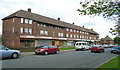
Parade of shops in Beechway
A shops and flats block similar and a little older than those featured in nearby Old Brumby; Image Part of the Lincoln Gardens estate which met the residential needs of the rapid expansion of the steel works in the early 1960's.
Image: © Jonathan Billinger
Taken: 1 May 2008
0.14 miles
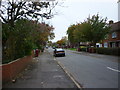
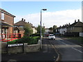
3
Lincoln Gardens
Post-War garden suburb housing in Lincoln Gardens
Image: © Richard Croft
Taken: 6 Mar 2009
0.16 miles
4
The Lincoln Imp, Lincoln Gardens, Scunthorpe
An estate pub built at the same time as the extensive housing of this part of Scunthorpe due to the rapid expansion of the Scunthorpe steel works in the early 1960's.
Image: © Jonathan Billinger
Taken: 1 May 2008
0.19 miles
5
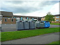
Recycling facilities
At Lincoln Court, Gloucester Road, Scunthorpe.
Image: © Jonathan Billinger
Taken: 1 May 2008
0.21 miles
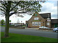
7
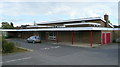
Alvingham Road Day Centre
Services for the elderly in Lincoln Gardens, Scunthorpe.
Image: © Jonathan Billinger
Taken: 1 May 2008
0.22 miles
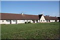
8
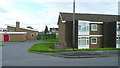
Lincoln Court, Peterborough Road, Scunthorpe
Sheltered housing adjacent to the Alvingham Road Day Care Centre to the left, Image
The flats to the right were built in 1967, as the photographer can clearly remember playing on the site as a child in the "summer of love"!
In the centre, behind, is the Lincoln Imp pub, Image
Image: © Jonathan Billinger
Taken: 1 May 2008
0.22 miles
10
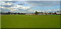
View across the playing fields
This shows the rear of St. Bede's Catholic School, with a distant view to the left of part of the steel works upon which Scunthorpe's economy depends.
Image: © Jonathan Billinger
Taken: 1 May 2008
0.25 miles