IMAGES TAKEN NEAR TO
Queen Street, SCUNTHORPE, DN15 9TT
Introduction
This page details the photographs taken nearby to Queen Street, DN15 9TT by members of the Geograph project.
The Geograph project started in 2005 with the aim of publishing, organising and preserving representative images for every square kilometre of Great Britain, Ireland and the Isle of Man.

There are currently over 7.5m images from over14,400 individuals and you can help contribute to the project by visiting https://www.geograph.org.uk
Image Map
Images are licensed for reuse under creativecommons.org/licenses/by-sa/2.0
Notes
- Clicking on the map will re-center to the selected point.
- The higher the marker number, the further away the image location is from the centre of the postcode.
Image Listing (116 Images Found)
Images are licensed for reuse under creativecommons.org/licenses/by-sa/2.0
Image
Details
Distance
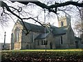
2
Winterton War Memorial
At All Saints Church, Winterton.
Image: © Ian S
Taken: 28 Sep 2016
0.02 miles
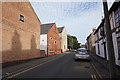
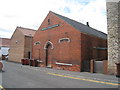
3
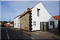
The former Jubilee Club
On Queen Street, Winterton.
Image: © Ian S
Taken: 28 Sep 2016
0.02 miles
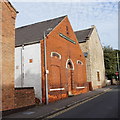
4
Former chapel, Queen Street, Winterton
Image: © Jonathan Thacker
Taken: 26 Jul 2010
0.03 miles
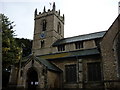
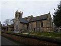
7
All Saints' church
Largely 13th & 14th century church with a mid-11th century tower
Image: © Richard Croft
Taken: 14 Mar 2013
0.03 miles
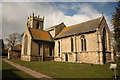
8
Church of All Saints
Grade I listed parish church dating from the 11th century
Image: © Graham Hogg
Taken: 24 Jan 2017
0.03 miles
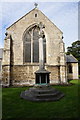
9
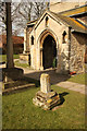
Churchyard cross
Grade II listed medieval cross base by All Saints' church, with about 0.5m of shaft remaining
Image: © Richard Croft
Taken: 14 Mar 2013
0.04 miles
10
Winterton village church yard closed
Image: © Steve Fareham
Taken: 22 Mar 2016
0.04 miles