IMAGES TAKEN NEAR TO
Winterton, SCUNTHORPE, DN15 9TF
Introduction
This page details the photographs taken nearby to DN15 9TF by members of the Geograph project.
The Geograph project started in 2005 with the aim of publishing, organising and preserving representative images for every square kilometre of Great Britain, Ireland and the Isle of Man.

There are currently over 7.5m images from over14,400 individuals and you can help contribute to the project by visiting https://www.geograph.org.uk
Image Map
Images are licensed for reuse under creativecommons.org/licenses/by-sa/2.0
Notes
- Clicking on the map will re-center to the selected point.
- The higher the marker number, the further away the image location is from the centre of the postcode.
Image Listing (14 Images Found)
Images are licensed for reuse under creativecommons.org/licenses/by-sa/2.0
Image
Details
Distance
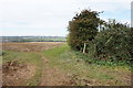
1
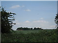
Old Cliff Farm
Seen from the course of the former North Lindsey Light Railway.
Image: © Jonathan Thacker
Taken: 30 Jun 2010
0.02 miles
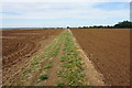
3
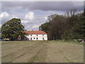
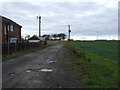
Old Cliff Farm
Old Cliff Farm on the outskirts of Winterton.
Image: © fred roberts
Taken: 21 May 2005
0.05 miles
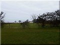
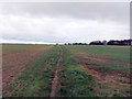
4
Bridleway to Winterton
Obviously frequented by off road bikers.
Image: © Steve Fareham
Taken: 22 Mar 2016
0.13 miles
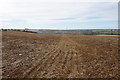
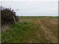
10
Track to Old Cliff Farm
Heading west off the A1077.
Image: © JThomas
Taken: 23 Nov 2013
0.22 miles