IMAGES TAKEN NEAR TO
Manlake Avenue, SCUNTHORPE, DN15 9SL
Introduction
This page details the photographs taken nearby to Manlake Avenue, DN15 9SL by members of the Geograph project.
The Geograph project started in 2005 with the aim of publishing, organising and preserving representative images for every square kilometre of Great Britain, Ireland and the Isle of Man.

There are currently over 7.5m images from over14,400 individuals and you can help contribute to the project by visiting https://www.geograph.org.uk
Image Map
Images are licensed for reuse under creativecommons.org/licenses/by-sa/2.0
Notes
- Clicking on the map will re-center to the selected point.
- The higher the marker number, the further away the image location is from the centre of the postcode.
Image Listing (42 Images Found)
Images are licensed for reuse under creativecommons.org/licenses/by-sa/2.0
Image
Details
Distance
4
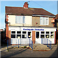
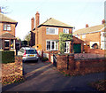
Earlsgate Fisheries
Pair of houses on Earlsgate Road converted to a Fish & Chip shop.
Image: © David Wright
Taken: 4 Nov 2006
0.11 miles
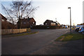
5
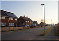
Houses on North side of Earlsgate Road
These houses on the North side of Earlsgate Road and have been built since the 1940's OS map was compiled, probably about 1955.
Image: © David Wright
Taken: 4 Nov 2006
0.12 miles
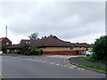
7

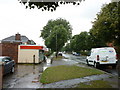
Driffil Way off Manlake Avenue, Winterton
Taken from the Opencast Way.
Image: © Ian S
Taken: 21 Mar 2016
0.12 miles
10

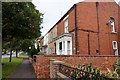
Earlsgate Junction
Taken from the A1077 looking down into Winterton.
Image: © fred roberts
Taken: 24 Apr 2004
0.14 miles