IMAGES TAKEN NEAR TO
Normanby, SCUNTHORPE, DN15 9HZ
Introduction
This page details the photographs taken nearby to DN15 9HZ by members of the Geograph project.
The Geograph project started in 2005 with the aim of publishing, organising and preserving representative images for every square kilometre of Great Britain, Ireland and the Isle of Man.

There are currently over 7.5m images from over14,400 individuals and you can help contribute to the project by visiting https://www.geograph.org.uk
Image Map (Loading...)


Getting Data...Please wait
Leaflet Map data © OpenStreetMap
Images are licensed for reuse under creativecommons.org/licenses/by-sa/2.0
Notes
- Clicking on the map will re-center to the selected point.
- The higher the marker number, the further away the image location is from the centre of the postcode.
Image Listing (21 Images Found)
Images are licensed for reuse under creativecommons.org/licenses/by-sa/2.0
Image
Details
Distance
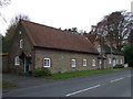
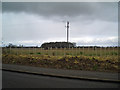
1
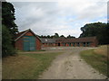
Stable block, Little Normanby Farm
Image: © Jonathan Thacker
Taken: 18 Jul 2010
0.07 miles
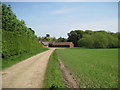
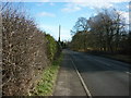
4
The Avenue, West of Normanby
Picture taken on the road called "The Avenue" between Normanby and Burton-Upon-Stather.
Image: © David Wright
Taken: 20 Mar 2006
0.10 miles
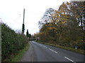
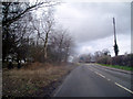
6
New Hedging
Newly planted hedging on the B1430 near Normanby. The copse is in SE8717.
Image: © David Wright
Taken: 20 Mar 2006
0.12 miles