IMAGES TAKEN NEAR TO
Farthing Avenue, SCUNTHORPE, DN15 8JY
Introduction
This page details the photographs taken nearby to Farthing Avenue, DN15 8JY by members of the Geograph project.
The Geograph project started in 2005 with the aim of publishing, organising and preserving representative images for every square kilometre of Great Britain, Ireland and the Isle of Man.

There are currently over 7.5m images from over14,400 individuals and you can help contribute to the project by visiting https://www.geograph.org.uk
Image Map (Loading...)


Getting Data...Please wait
Leaflet Map data © OpenStreetMap
Images are licensed for reuse under creativecommons.org/licenses/by-sa/2.0
Notes
- Clicking on the map will re-center to the selected point.
- The higher the marker number, the further away the image location is from the centre of the postcode.
Image Listing (28 Images Found)
Images are licensed for reuse under creativecommons.org/licenses/by-sa/2.0
Image
Details
Distance
1
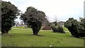
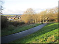
Green space between Berkeley and Crosby, Scunthorpe
Image: © Chris Morgan
Taken: 23 Jan 2018
0.12 miles
2
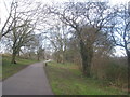
The Ridgeway Cycle Path
Passing through the Hempdykes. The Ridgeway Cycle Path links the western fringe of Scunthorpe with the industrial area to the north of the town.
Image: © Jonathan Thacker
Taken: 3 Mar 2014
0.12 miles
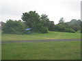
4
Footpath and cycle path to Avenue Vivian
The houses on the right are on Hempdyke Road.
Image: © Jonathan Thacker
Taken: 20 May 2015
0.13 miles
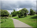
5
Ridgeway Cycle Path
Crossing the Hempdykes.
Image: © Jonathan Thacker
Taken: 24 Dec 2014
0.13 miles
7
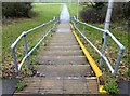
Flight of steps in urban green space
Presumably the yellow trough is to assist cyclists?
Image: © Graham Hogg
Taken: 23 Jan 2018
0.15 miles
8
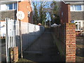
Path and steps to the Hempdykes from Sherburn Crescent
The Hempdykes is an area of grass, shrubs and woodland along the low escarpment above the Trent Valley.
Image: © Jonathan Thacker
Taken: 13 Jan 2014
0.15 miles
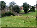
9

Snow on the Hempdykes
Looking towards Sherburn Crescent.
Image: © Jonathan Thacker
Taken: 3 Dec 2010
0.16 miles
10

Footpath delayed
The heavy snowfall has brought construction of a new footpath from Avenue Vivian to Sherburn Crescent to a halt. This footpath is mainly for the benefit of the increasing number of pupils from Crosby who are going to the primary schools on the Berkeley estate and students from that estate attending ftc (Foxhills Technology College). The footpath which runs from Ferry Road across the Hempdykes to Cliff Closes Road is also being improved.
Image: © Jonathan Thacker
Taken: 3 Dec 2010
0.16 miles