IMAGES TAKEN NEAR TO
High Santon Villas, SCUNTHORPE, DN15 0DG
Introduction
This page details the photographs taken nearby to High Santon Villas, DN15 0DG by members of the Geograph project.
The Geograph project started in 2005 with the aim of publishing, organising and preserving representative images for every square kilometre of Great Britain, Ireland and the Isle of Man.

There are currently over 7.5m images from over14,400 individuals and you can help contribute to the project by visiting https://www.geograph.org.uk
Image Map (Loading...)


Getting Data...Please wait
Leaflet Map data © OpenStreetMap
Images are licensed for reuse under creativecommons.org/licenses/by-sa/2.0
Notes
- Clicking on the map will re-center to the selected point.
- The higher the marker number, the further away the image location is from the centre of the postcode.
Image Listing (17 Images Found)
Images are licensed for reuse under creativecommons.org/licenses/by-sa/2.0
Image
Details
Distance
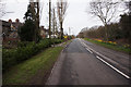
1
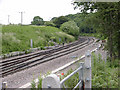
Railway just North of Dawes Lane, Santon
This is the rail line that carries iron ore from Immingham Terminal to the Corus steelworks.
Image: © David Wright
Taken: 18 Jun 2006
0.02 miles
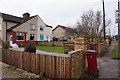
2
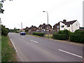
Santon
Picture taken looking approx. East.
Image: © David Wright
Taken: 18 Jun 2006
0.02 miles
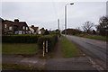
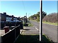
4
Housing at Santon
View east on Dawes Road, within earshot and smelling distance of the heavy industry of Scunthorpe steelworks.
Image: © Jonathan Billinger
Taken: 9 Apr 2008
0.05 miles

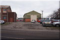
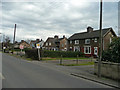
10
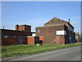
Santon Business Park
The few occupied buildings seem to be largely car repairers.
Image: © Jonathan Thacker
Taken: 15 Apr 2019
0.17 miles