IMAGES TAKEN NEAR TO
Broughton Road, SCUNTHORPE, DN15 0DD
Introduction
This page details the photographs taken nearby to Broughton Road, DN15 0DD by members of the Geograph project.
The Geograph project started in 2005 with the aim of publishing, organising and preserving representative images for every square kilometre of Great Britain, Ireland and the Isle of Man.

There are currently over 7.5m images from over14,400 individuals and you can help contribute to the project by visiting https://www.geograph.org.uk
Image Map
Images are licensed for reuse under creativecommons.org/licenses/by-sa/2.0
Notes
- Clicking on the map will re-center to the selected point.
- The higher the marker number, the further away the image location is from the centre of the postcode.
Image Listing (12 Images Found)
Images are licensed for reuse under creativecommons.org/licenses/by-sa/2.0
Image
Details
Distance
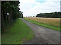
2
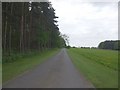
Track to Spring Wood Lodge.
Photo taken from the B1207.
Image: © David Wright
Taken: 25 Jul 2009
0.18 miles
5
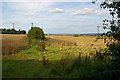
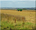
Harvesting Oilseed Rape
Photo taken from NE corner of Santon Wood.
Image: © David Wright
Taken: 8 Aug 2009
0.22 miles
6
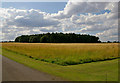
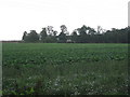
Broom Hill near Santon
Photo taken from a position where the track to Spring Wood Cottage joins the B1207.
Image: © David Wright
Taken: 25 Jul 2009
0.22 miles
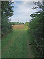
7
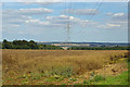
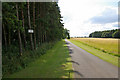
Power Lines near Santon Wood
Power lines crossing a field of Oilseed Rape.
Image: © David Wright
Taken: 8 Aug 2009
0.22 miles
9
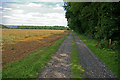
Lodge Farm Permissive Footpath
The wood to the right is Heron Holt.
Image: © David Wright
Taken: 8 Aug 2009
0.23 miles