IMAGES TAKEN NEAR TO
Weeland Villas, GOOLE, DN14 9LA
Introduction
This page details the photographs taken nearby to Weeland Villas, DN14 9LA by members of the Geograph project.
The Geograph project started in 2005 with the aim of publishing, organising and preserving representative images for every square kilometre of Great Britain, Ireland and the Isle of Man.

There are currently over 7.5m images from over14,400 individuals and you can help contribute to the project by visiting https://www.geograph.org.uk
Image Map
Images are licensed for reuse under creativecommons.org/licenses/by-sa/2.0
Notes
- Clicking on the map will re-center to the selected point.
- The higher the marker number, the further away the image location is from the centre of the postcode.
Image Listing (42 Images Found)
Images are licensed for reuse under creativecommons.org/licenses/by-sa/2.0
Image
Details
Distance
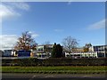
3
Snaith Grammar School
Dating from 1878 but no longer a school building
Image: © Graham Hogg
Taken: 30 Jun 2015
0.06 miles
7
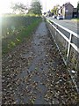
Pedestrian barrier alongside the A645 Snaith
Image: © Steve Fareham
Taken: 1 Nov 2014
0.14 miles
8
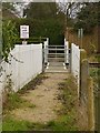
Pedestrian level crossing
Public footpath between Gowdall Lane and Horse Chestnut Lane.
Image: © Alan Murray-Rust
Taken: 28 Dec 2018
0.15 miles
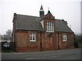
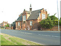
9

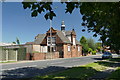
Brewers Arms, Snaith
This is the brewery tap of the Old Mill Brewery.
The building was originally Snaith House, a fine 5-bay, 3-storey Georgian house of the mid to late 18th century. The Historic England listing describes the windows as “Unsympathetic C20 casements” but it is clear that some effort has been made to improve the situation with imitation glazing bars added. At the time of listing the building was in use as a club, and known as The Lodge. Listed Grade II.
Image: © Alan Murray-Rust
Taken: 28 Jul 2016
0.16 miles