IMAGES TAKEN NEAR TO
High Street, GOOLE, DN14 9HF
Introduction
This page details the photographs taken nearby to High Street, DN14 9HF by members of the Geograph project.
The Geograph project started in 2005 with the aim of publishing, organising and preserving representative images for every square kilometre of Great Britain, Ireland and the Isle of Man.

There are currently over 7.5m images from over14,400 individuals and you can help contribute to the project by visiting https://www.geograph.org.uk
Image Map
Images are licensed for reuse under creativecommons.org/licenses/by-sa/2.0
Notes
- Clicking on the map will re-center to the selected point.
- The higher the marker number, the further away the image location is from the centre of the postcode.
Image Listing (94 Images Found)
Images are licensed for reuse under creativecommons.org/licenses/by-sa/2.0
Image
Details
Distance
1
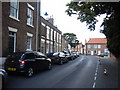
5, 7, & 9 High Street, Snaith
No.5 (nearest) is an attractive 5-bay early Georgian house; Nos.7 & 9 beyond are slightly later, mid 18th century, all Listed Grade II.
Image: © Alan Murray-Rust
Taken: 28 Jul 2016
0.01 miles
2
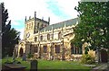
Snaith, The Priory Church of St Laurence
Image: © Bill Henderson
Taken: Unknown
0.01 miles
4

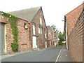
1 & 3 Church Lane, Snaith
Built as a single house around 1700, it has been much altered since. By the late 20th century, it had become two dwellings, the corner house also having a shop front on the Church Lane face. When listed in the 1980s, the outside was finished in render. Listed Grade II.
Image: © Alan Murray-Rust
Taken: 28 Jul 2016
0.02 miles
5

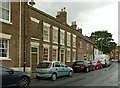
Nos.15 (April Cottage) & 13, High Street, Snaith
A pair of colour-washed cottages from the early part of the 18th century, of which no.13 retains a pair of early 19th century bowed shop windows. Both Listed Grade II.
Image: © Alan Murray-Rust
Taken: 28 Jul 2016
0.02 miles
6

High Street, Snaith
No.1 (with black paintwork) is a late 18th century house, converted to a shop in the mid to late 19th century. No.3, beyond, is a typical Georgian 3 storey town house of 4 bays, originally the vicarage, and of similar mid-18th century date. Both are Listed Grade II.
Image: © Alan Murray-Rust
Taken: 28 Jul 2016
0.03 miles
7

Church of St Lawrence, Snaith, west doorway
Dating from the construction of the tower in the 13th century.
There is a bench mark http://www.geograph.org.uk/photo/5056981 just to the right of the doorway.
Image: © Alan Murray-Rust
Taken: 28 Jul 2016
0.03 miles
8

1GL bench mark with bolt, Church of St Lawrence, Snaith
See http://www.geograph.org.uk/photo/5056994 for location.
Image: © Alan Murray-Rust
Taken: 28 Jul 2016
0.03 miles
9

Altar tombs in the churchyard, Snaith
The group of three slabs in the foreground, and the similar group in the right background, date from the mid to late 18th century and are separately Listed Grade II.
Image: © Alan Murray-Rust
Taken: 28 Jul 2016
0.03 miles