IMAGES TAKEN NEAR TO
Back Lane, GOOLE, DN14 9ET
Introduction
This page details the photographs taken nearby to Back Lane, DN14 9ET by members of the Geograph project.
The Geograph project started in 2005 with the aim of publishing, organising and preserving representative images for every square kilometre of Great Britain, Ireland and the Isle of Man.

There are currently over 7.5m images from over14,400 individuals and you can help contribute to the project by visiting https://www.geograph.org.uk
Image Map
Images are licensed for reuse under creativecommons.org/licenses/by-sa/2.0
Notes
- Clicking on the map will re-center to the selected point.
- The higher the marker number, the further away the image location is from the centre of the postcode.
Image Listing (11 Images Found)
Images are licensed for reuse under creativecommons.org/licenses/by-sa/2.0
Image
Details
Distance
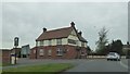
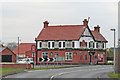
2
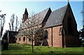
Former Bay Horse pub at East Cowick
Now a restaurant
Image: © John Slater
Taken: 7 Aug 2019
0.14 miles
4

The drain alongside Dowson's Lane
The M62 is just out of sight to the left.
Image: © Jonathan Thacker
Taken: 10 Dec 2011
0.16 miles
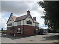
5
East Cowick Near Goole, Bay Horse Public House
Image: © Gordon Kneale Brooke
Taken: 10 Dec 2005
0.16 miles
6

Goathead Lane
The truncated northern section.
Image: © Jonathan Thacker
Taken: 10 Dec 2011
0.21 miles
8

Milepost at East Cowick
Cast iron milepost of the Selby and Bawtry turnpike, Listed Grade II.
Image: © Alan Murray-Rust
Taken: 28 Jul 2016
0.24 miles
9
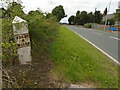
Old milepost
On the south side of the A1041 opposite East Cowick Primary School. Since this milepost was last painted in 2016 by a Milestone Society member, a hedgerow has grown round it so it is not so obvious. This one and the milepost at the west end of Snaith (SE 6467 2197) are the only ones of this design with a pointed top, that remain on the Bawtry, Thorne, Selby turnpike route. This may suggest that they were set up by the newly formed East Riding CC in the late 19C. Grade II listed 1083326.
Image: © Chris Minto
Taken: 28 Aug 2023
0.24 miles
10
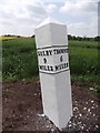
Old Milepost by the A1041, Snaith Road, East Cowick
Cast iron post by the A1041, in parish of SNAITH AND COWICK (EAST RIDING OF YORKSHIRE District), 50m South East of Primary School, East Cowick, in the verge, on South side of road. Selby casting, erected by the Bawtry & Selby turnpike trust in the 19th century.
Inscription reads:-
: SELBY / 9 / MILES : : THORNE / 6 / MILES :
Grade II listed. List Entry Number: 1083326
https://historicengland.org.uk/listing/the-list/list-entry/1083326
Milestone Society National ID: YE_SYTH09.
Image: © J Harland & C Minto
Taken: 1 May 2002
0.24 miles