IMAGES TAKEN NEAR TO
Cowick Road, GOOLE, DN14 9DN
Introduction
This page details the photographs taken nearby to Cowick Road, DN14 9DN by members of the Geograph project.
The Geograph project started in 2005 with the aim of publishing, organising and preserving representative images for every square kilometre of Great Britain, Ireland and the Isle of Man.

There are currently over 7.5m images from over14,400 individuals and you can help contribute to the project by visiting https://www.geograph.org.uk
Image Map
Images are licensed for reuse under creativecommons.org/licenses/by-sa/2.0
Notes
- Clicking on the map will re-center to the selected point.
- The higher the marker number, the further away the image location is from the centre of the postcode.
Image Listing (13 Images Found)
Images are licensed for reuse under creativecommons.org/licenses/by-sa/2.0
Image
Details
Distance
1
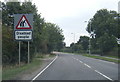
A1041 leaving Snaith at a large warning sign
Image: © Colin Pyle
Taken: 15 Sep 2018
0.06 miles
3
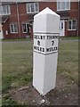
Old Milepost by the A1041, Goole Road, Snaith
Cast iron post by the A1041, in parish of SNAITH AND COWICK (EAST RIDING OF YORKSHIRE District), 50m East of Onnsley, 75m West of Fairholme, Goole Road, Snaith, on the verge in front of houses built since 2003, on South side of road. Selby casting, erected by the Bawtry & Selby turnpike trust in the 19th century.
Inscription reads:-
: SELBY / 8 / MILES : : THORNE / 7 / MILES :
Grade II Listed. List Entry Number: 1161892
https://historicengland.org.uk/listing/the-list/list-entry/1161892
Milestone Society National ID: YE_SYTH08.
Image: © J Harland & C Minto
Taken: 1 May 2002
0.07 miles
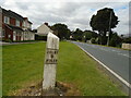
4
Old Milepost by the A1041, Goole Road, Snaith
Cast iron post by the A1041, in parish of SNAITH AND COWICK (EAST RIDING OF YORKSHIRE District), 50m East of Onnsley, 75m West of Fairholme, Goole Road, Snaith, on the verge in front of houses built since 2003, on South side of road. Selby casting, erected by the Bawtry & Selby turnpike trust in the 19th century. An earlier photograph can be found here https://www.geograph.org.uk/photo/6045233.
Inscription reads:-
: SELBY / 8 / MILES : : THORNE / 7 / MILES :
Grade II Listed. List Entry Number: 1161892 https://historicengland.org.uk/listing/the-list/list-entry/1161892
Milestone Society National ID: YE_SYTH08.
Image: © Peter Sharp
Taken: 22 Aug 2023
0.07 miles
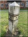
5
Old milestone
Looking towards the centre of Snaith along the A1041 by Brierley Close. This milepost was reset when the houses behind it were built after 2003. It was last painted by a Milestone Society member in 2016. Now leaning slightly and needing repainting. Of the few mileposts remaining on the 28.5 mile turnpike route Selby, Thorne and Bawtry, first enacted 1793, only this one and Selby 9 at East Cowick (SE 6619 2153) both in the old East Yorkshire, are of this design with an angled top. Grade II listed 1161892.
Image: © Chris Minto
Taken: 28 Aug 2023
0.08 miles
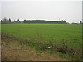

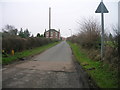
8
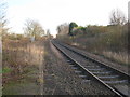
The railway towards Goole
There is only one passenger train to Goole Monday to Fridays, and two in the return direction.
Image: © Jonathan Thacker
Taken: 10 Dec 2011
0.21 miles