IMAGES TAKEN NEAR TO
Beevers Bridge, GOOLE, DN14 9AB
Introduction
This page details the photographs taken nearby to Beevers Bridge, DN14 9AB by members of the Geograph project.
The Geograph project started in 2005 with the aim of publishing, organising and preserving representative images for every square kilometre of Great Britain, Ireland and the Isle of Man.

There are currently over 7.5m images from over14,400 individuals and you can help contribute to the project by visiting https://www.geograph.org.uk
Image Map
Images are licensed for reuse under creativecommons.org/licenses/by-sa/2.0
Notes
- Clicking on the map will re-center to the selected point.
- The higher the marker number, the further away the image location is from the centre of the postcode.
Image Listing (17 Images Found)
Images are licensed for reuse under creativecommons.org/licenses/by-sa/2.0
Image
Details
Distance
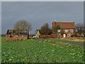
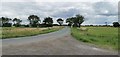
2
Between Rivers Farm, from the north
Seen from South Field Lane. The land is 4 metres above sea level.
Image: © Christine Johnstone
Taken: 13 Sep 2019
0.02 miles
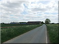
3
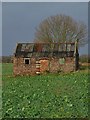
Old farm building at Between Rivers Farm
Seen across a field of winter beet
Image: © Neil Theasby
Taken: 30 Dec 2017
0.03 miles
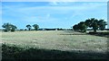
5
Oak Lane
Looking towards Between Rivers Farm
Image: © Chris Morgan
Taken: 6 Jul 2020
0.03 miles
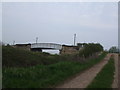
7
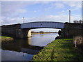
Beevers bridge.
Beside the Aire and Calder.
Image: © steven ruffles
Taken: 10 Feb 2010
0.13 miles
8
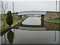
Beever's Bridge from the east
Carrying Oak Lane over the Aire and Calder Navigation. Seen from the barge Sobriety, heading from Goole to Sprotbrough.
Image: © Christine Johnstone
Taken: 4 Apr 2014
0.15 miles
10
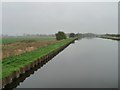
Aire & Calder Navigation, west of Beever's Bridge
Seen from the barge Sobriety, heading from Goole to Sprotbrough.
Image: © Christine Johnstone
Taken: 4 Apr 2014
0.16 miles