IMAGES TAKEN NEAR TO
Snaith Road, GOOLE, DN14 8NA
Introduction
This page details the photographs taken nearby to Snaith Road, DN14 8NA by members of the Geograph project.
The Geograph project started in 2005 with the aim of publishing, organising and preserving representative images for every square kilometre of Great Britain, Ireland and the Isle of Man.

There are currently over 7.5m images from over14,400 individuals and you can help contribute to the project by visiting https://www.geograph.org.uk
Image Map
Images are licensed for reuse under creativecommons.org/licenses/by-sa/2.0
Notes
- Clicking on the map will re-center to the selected point.
- The higher the marker number, the further away the image location is from the centre of the postcode.
Image Listing (15 Images Found)
Images are licensed for reuse under creativecommons.org/licenses/by-sa/2.0
Image
Details
Distance
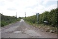
1
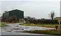
The entrance to Hazel Bank Farm
With a new unmapped shed close to the A614.
Image: © Christine Johnstone
Taken: 18 Jan 2017
0.05 miles
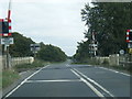
2
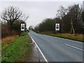
Warning of a level crossing on the A614
The road has been raised to create the crossing. These sideways flashing red lights are the only type that emergency services must stop at.
Image: © Christine Johnstone
Taken: 18 Jan 2017
0.08 miles
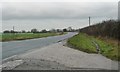
3
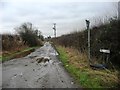
The original Mill Lane, near Rawcliffe
Running south-east from the A614 near Hazel Bank Farm, now bisected by the railway line where once there was a level crossing. The newer Mill Lane keeps to the south side of the railway.
Image: © Christine Johnstone
Taken: 18 Jan 2017
0.11 miles
5
A614 heading to Rawcliffe
About 4 metres above sea level.
Image: © Christine Johnstone
Taken: 18 Jan 2017
0.11 miles
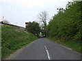
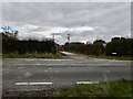
9
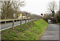
Road on embankment
The embankment raises the road, the A614, to the height of the railway ahead so necessitating a level crossing. The much more minor road at the right side of the image passes beneath the railway which crosses it by a bridge.
Image: © Trevor Littlewood
Taken: 10 Mar 2016
0.16 miles
10
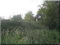
A sign of the railway
Growth of vegetation the embankment is such that only this sign gives any indication that there is a railway still on top of it.
The sign is a "Fixed Distant" board, and gives advanced warning that trains should be prepared to stop ahead, in this case at Rawcliffe Bridge station and the level crossing by it.
Image: © Jonathan Thacker
Taken: 1 Jul 2012
0.16 miles