IMAGES TAKEN NEAR TO
Ousefleet, GOOLE, DN14 8HW
Introduction
This page details the photographs taken nearby to DN14 8HW by members of the Geograph project.
The Geograph project started in 2005 with the aim of publishing, organising and preserving representative images for every square kilometre of Great Britain, Ireland and the Isle of Man.

There are currently over 7.5m images from over14,400 individuals and you can help contribute to the project by visiting https://www.geograph.org.uk
Image Map
Images are licensed for reuse under creativecommons.org/licenses/by-sa/2.0
Notes
- Clicking on the map will re-center to the selected point.
- The higher the marker number, the further away the image location is from the centre of the postcode.
Image Listing (20 Images Found)
Images are licensed for reuse under creativecommons.org/licenses/by-sa/2.0
Image
Details
Distance
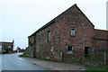
1
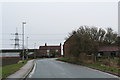
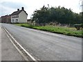
Farm and house on the road into Ousefleet from the west
The road is called "Pennyhill Cottages".
Image: © Chris
Taken: 5 Jan 2014
0.03 miles
2
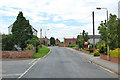
Ousefleet
Photo taken near the Old School Image looking towards Whitgift.
Image: © David Wright
Taken: 27 Jul 2007
0.04 miles
5
Barn at West View Farm
On the way into Ousefleet from the west.
The road is called "Pennyhill Cottages".
Image: © Chris
Taken: 5 Jan 2014
0.06 miles
6
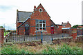
The Old School, Ousefleet
There is a date stone of 1875. This building is marked on the current map as "Marshland Community Centre" but appears not to be in use.
Image: © David Wright
Taken: 27 Jul 2007
0.08 miles
7
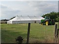
Ousefleet's community field
The marquee [and possibly the tractor] remain from yesterday's village show.
Image: © Christine Johnstone
Taken: 15 Aug 2010
0.12 miles
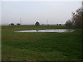
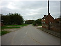
9
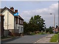
Ousefleet's main road
The road runs almost parallel to the flood bank, but well inland.
Image: © Christine Johnstone
Taken: 15 Aug 2010
0.14 miles
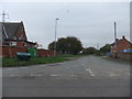
10
Flying the flag
Once in the West Riding, now in the East Riding, this Ousefleet house proudly flies the Yorkshire flag.
Image: © Christine Johnstone
Taken: 15 Aug 2010
0.16 miles