IMAGES TAKEN NEAR TO
Reedness, GOOLE, DN14 8ET
Introduction
This page details the photographs taken nearby to DN14 8ET by members of the Geograph project.
The Geograph project started in 2005 with the aim of publishing, organising and preserving representative images for every square kilometre of Great Britain, Ireland and the Isle of Man.

There are currently over 7.5m images from over14,400 individuals and you can help contribute to the project by visiting https://www.geograph.org.uk
Image Map
Images are licensed for reuse under creativecommons.org/licenses/by-sa/2.0
Notes
- Clicking on the map will re-center to the selected point.
- The higher the marker number, the further away the image location is from the centre of the postcode.
Image Listing (47 Images Found)
Images are licensed for reuse under creativecommons.org/licenses/by-sa/2.0
Image
Details
Distance
3
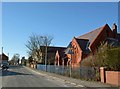
Reedness redbrick Wesleyan chapel
Dated 1904.
Image: © Steve Fareham
Taken: 7 Mar 2010
0.04 miles
4

Wesleyan Chapel in Reedness
A small chapel named and dated 1904 in brickwork above the door.
Image: © Trevor Littlewood
Taken: 26 Dec 2010
0.05 miles
5
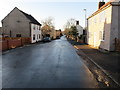
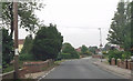
Main Street, Reedness
Looking north-westward.
Image: © Peter Wood
Taken: 30 Nov 2019
0.07 miles
6
Old Hill Cottages at Old Lane junction
At Reedness
Image: © John Firth
Taken: 10 Jun 2013
0.10 miles
7
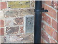
Ordnance Survey Flush Bracket G2450
This bracket can be found on the wall of a house - private dwelling - in Main Street, Reedness. The benchmark's recorded height is 4.204 metres above sea level.
For more detail see : https://www.bench-marks.org.uk/bm14606
Image: © Peter Wood
Taken: 30 Nov 2019
0.10 miles
8
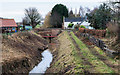
Reedness Drain
Reedness Drain and a few houses of the village seen from a path along the flood defence of the south side of the River Ouse.
Image: © Trevor Littlewood
Taken: 12 Dec 2019
0.11 miles
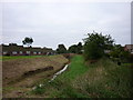
10
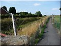
Footpath alongside Reedness Drain
This links the main road to the flood bank.
Image: © Christine Johnstone
Taken: 15 Aug 2010
0.11 miles