IMAGES TAKEN NEAR TO
Goole Fields, GOOLE, DN14 8BA
Introduction
This page details the photographs taken nearby to DN14 8BA by members of the Geograph project.
The Geograph project started in 2005 with the aim of publishing, organising and preserving representative images for every square kilometre of Great Britain, Ireland and the Isle of Man.

There are currently over 7.5m images from over14,400 individuals and you can help contribute to the project by visiting https://www.geograph.org.uk
Image Map
Images are licensed for reuse under creativecommons.org/licenses/by-sa/2.0
Notes
- Clicking on the map will re-center to the selected point.
- The higher the marker number, the further away the image location is from the centre of the postcode.
Image Listing (3 Images Found)
Images are licensed for reuse under creativecommons.org/licenses/by-sa/2.0
Image
Details
Distance
2
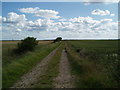
Bend of farm road beside Earnshaw's Warping Drain
The area known as Goole Fields, south of the town, is flat and low lying farmland. Individual farms are served by long access roads; this is one of them. The view is to the north-west where the road bends as it reaches Earnshaw's Warping Drain which lies beyond the raised bank.
Image: © Trevor Littlewood
Taken: 6 Nov 2013
0.20 miles