IMAGES TAKEN NEAR TO
Goole Road, GOOLE, DN14 8AR
Introduction
This page details the photographs taken nearby to Goole Road, DN14 8AR by members of the Geograph project.
The Geograph project started in 2005 with the aim of publishing, organising and preserving representative images for every square kilometre of Great Britain, Ireland and the Isle of Man.

There are currently over 7.5m images from over14,400 individuals and you can help contribute to the project by visiting https://www.geograph.org.uk
Image Map
Images are licensed for reuse under creativecommons.org/licenses/by-sa/2.0
Notes
- Clicking on the map will re-center to the selected point.
- The higher the marker number, the further away the image location is from the centre of the postcode.
Image Listing (72 Images Found)
Images are licensed for reuse under creativecommons.org/licenses/by-sa/2.0
Image
Details
Distance
1
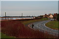
Road into Swinefleet
Red winter dogwood shoots and the River Ouse.
Image: © Chris
Taken: 5 Jan 2014
0.02 miles
2
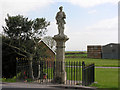
War Memorial at Swinefleet
Standing on the south-western edge of the village, this soldier looks out onto the Ouse across the intervening dyke. Passing ships can see the man but not the column, so he appears as a lone figure keeping a vigil on the dyke.
Image: © George Robinson
Taken: 11 Apr 2007
0.03 miles
3
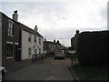
Swinefleet High Street
This was once the main thoroughfare of the village but was closed to through traffic a few years back. Now, as this picture shows, part of the High Street has been annexed as a private garden.
Image: © Jonathan Thacker
Taken: 11 Mar 2011
0.03 miles
4
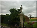
War memorial, Swinefleet
The A161 entering Swinefleet from the south-west passes the village war memorial. The statue atop the column has seen better days; there are signs of erosion to the figure and the rifle has lost its barrel though according to local information it's in safe-keeping, stored in the workshop of one of the residents.
To the left of the image is a levee of the River Ouse which was raised in recent years; a piece of civil engineering which almost certainly saved the village from flooding during the 'storm surge' of December 2013.
Image: © Trevor Littlewood
Taken: 23 Jan 2014
0.04 miles
5
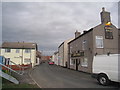
The Kings Head and Swinefleet High Street
Once the main thoroughfare of the village High Street is now blocked at its western end.
Image: © Jonathan Thacker
Taken: 11 Mar 2011
0.05 miles
6
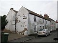
Another "Pub with No Beer" The George Inn Swinefleet
Looking for a developer to take it out of its misery
Image: © Martin Dawes
Taken: 7 Mar 2018
0.05 miles
7
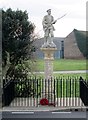
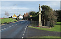
Swinefleet War Memorial Goole Road A161 Swinefleet
Image: © Martin Dawes
Taken: 7 Mar 2018
0.05 miles
9
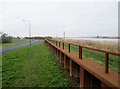
Heightened flood defence Swinefleet
This sheet piling has been put into the top of the flood bank to raise the height of the flood defence, to the left is the A161 Goole Road
Image: © Martin Dawes
Taken: 7 Mar 2018
0.06 miles
10
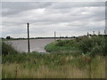
View along the Ouse towards Swinefleet
Image: © Jonathan Thacker
Taken: 16 Jul 2010
0.07 miles