IMAGES TAKEN NEAR TO
Council Houses, GOOLE, DN14 7NL
Introduction
This page details the photographs taken nearby to Council Houses, DN14 7NL by members of the Geograph project.
The Geograph project started in 2005 with the aim of publishing, organising and preserving representative images for every square kilometre of Great Britain, Ireland and the Isle of Man.

There are currently over 7.5m images from over14,400 individuals and you can help contribute to the project by visiting https://www.geograph.org.uk
Image Map
Images are licensed for reuse under creativecommons.org/licenses/by-sa/2.0
Notes
- Clicking on the map will re-center to the selected point.
- The higher the marker number, the further away the image location is from the centre of the postcode.
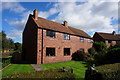
Image Listing (21 Images Found)
Images are licensed for reuse under creativecommons.org/licenses/by-sa/2.0
Image
Details
Distance
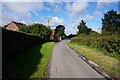
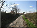
3
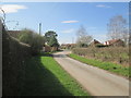
Ings Lane in Spaldington
The Howden 20 long distance footpath crosses the lane here, the finger post can be seen at the end of the hedge on the right.
Image: © Martin Dawes
Taken: 20 Mar 2019
0.03 miles