IMAGES TAKEN NEAR TO
Vicar Lane, GOOLE, DN14 7BP
Introduction
This page details the photographs taken nearby to Vicar Lane, DN14 7BP by members of the Geograph project.
The Geograph project started in 2005 with the aim of publishing, organising and preserving representative images for every square kilometre of Great Britain, Ireland and the Isle of Man.

There are currently over 7.5m images from over14,400 individuals and you can help contribute to the project by visiting https://www.geograph.org.uk
Image Map
Images are licensed for reuse under creativecommons.org/licenses/by-sa/2.0
Notes
- Clicking on the map will re-center to the selected point.
- The higher the marker number, the further away the image location is from the centre of the postcode.
Image Listing (366 Images Found)
Images are licensed for reuse under creativecommons.org/licenses/by-sa/2.0
Image
Details
Distance
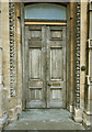
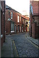
1
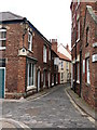
Vicar Lane, Howden
One of several narrow streets and alleyways in the centre of this small town. Development here was probably due to gradual infilling of a once much larger Market Place.
Image: © Gordon Hatton
Taken: 28 May 2009
0.01 miles
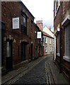
3
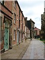
Churchside, Howden
Pedestrianised area along the north side of the Minster. Some attractive red brick buildings on the left which show signs of recent restoration work.
Image: © Gordon Hatton
Taken: 28 May 2009
0.01 miles
4
Pile of Pumpkins
Variously sized and priced pumpkins await their end-of-month mutilation outside an Howden shop!
Image: © Andy Beecroft
Taken: 30 Oct 2009
0.01 miles
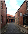
6
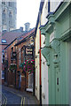
Vicar Lane, Howden
Immediately to the north of Howden Minster is an area of narrow streets and alleys including Vicar Lane. The tower of the minster overlooks the scene. It is believed that the area may have been an infilling of a large early medieval market place where permanent shops replaced moveable stalls. Several businesses can be seen in this view including Jamil Spice and Peel & Ash, both restaurants.
Image: © Stephen McKay
Taken: 20 Sep 2019
0.01 miles
8
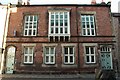
10-11 Churchside
Built in the early 1850s, this became known as The Town Hall. The upper floor was used as a magistrate's court and for lectures, concerts and vestry meetings. The ground floor was divided between Howdenshire Savings Bank and The Mechanic's Institute, the latter becoming a WVS clothing store during the Second World War
Image: © Richard Croft
Taken: 4 Dec 2009
0.01 miles
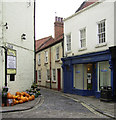
10
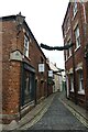
Vicar Lane
Looking along Vicar Lane leading to Market Place in Howden.
Image: © DS Pugh
Taken: 30 Aug 2021
0.01 miles