IMAGES TAKEN NEAR TO
Swan Lane, GOOLE, DN14 6WD
Introduction
This page details the photographs taken nearby to Swan Lane, DN14 6WD by members of the Geograph project.
The Geograph project started in 2005 with the aim of publishing, organising and preserving representative images for every square kilometre of Great Britain, Ireland and the Isle of Man.

There are currently over 7.5m images from over14,400 individuals and you can help contribute to the project by visiting https://www.geograph.org.uk
Image Map
Images are licensed for reuse under creativecommons.org/licenses/by-sa/2.0
Notes
- Clicking on the map will re-center to the selected point.
- The higher the marker number, the further away the image location is from the centre of the postcode.
Image Listing (6 Images Found)
Images are licensed for reuse under creativecommons.org/licenses/by-sa/2.0
Image
Details
Distance
1
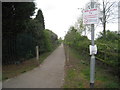
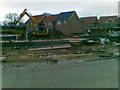
"Dog Crap Alley"
I wonder of this will ever become its official name?
Image: © Jonathan Thacker
Taken: 5 May 2012
0.10 miles
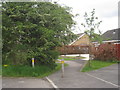
3
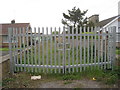
Gates to nowhere
This appears to be an access to the cricket field beyond, but a pavilion has been built at the end which blocks the way.
Image: © Jonathan Thacker
Taken: 5 May 2012
0.15 miles
4
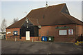
Goole and District Hospital
Main entrance to the hospital on Woodland Avenue: http://www.nlg.nhs.uk/contact/gdh.asp
Image: © Paul Harrop
Taken: 28 Mar 2010
0.15 miles
6
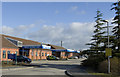
The two Carr Lanes
Carr Lane is divided into two parts which are connected by a very short stretch of footpath,
Image: © Jonathan Thacker
Taken: 5 May 2012
0.24 miles