IMAGES TAKEN NEAR TO
Belvedere Crescent, GOOLE, DN14 6PT
Introduction
This page details the photographs taken nearby to Belvedere Crescent, DN14 6PT by members of the Geograph project.
The Geograph project started in 2005 with the aim of publishing, organising and preserving representative images for every square kilometre of Great Britain, Ireland and the Isle of Man.

There are currently over 7.5m images from over14,400 individuals and you can help contribute to the project by visiting https://www.geograph.org.uk
Image Map
Images are licensed for reuse under creativecommons.org/licenses/by-sa/2.0
Notes
- Clicking on the map will re-center to the selected point.
- The higher the marker number, the further away the image location is from the centre of the postcode.
Image Listing (19 Images Found)
Images are licensed for reuse under creativecommons.org/licenses/by-sa/2.0
Image
Details
Distance
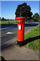
5
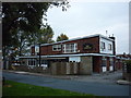
The Viking public house on Airmyn Road, Goole
Image: © Ian S
Taken: 15 Oct 2010
0.19 miles
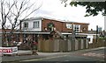
10
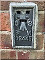
Flush Bracket OSBM G2445: Goole, Osborne House
This flush bracket benchmark is on the side of a garage in Airmyn Road. See https://www.geograph.org.uk/photo/7312273 for a wider view and https://www.bench-marks.org.uk/bm14602 for details of the mark.
Image: © Brian Westlake
Taken: 16 Sep 2022
0.19 miles