IMAGES TAKEN NEAR TO
DN14 6GG
Introduction
This page details the photographs taken nearby to DN14 6GG by members of the Geograph project.
The Geograph project started in 2005 with the aim of publishing, organising and preserving representative images for every square kilometre of Great Britain, Ireland and the Isle of Man.

There are currently over 7.5m images from over14,400 individuals and you can help contribute to the project by visiting https://www.geograph.org.uk
Image Map
Images are licensed for reuse under creativecommons.org/licenses/by-sa/2.0
Notes
- Clicking on the map will re-center to the selected point.
- The higher the marker number, the further away the image location is from the centre of the postcode.
Image Listing (53 Images Found)
Images are licensed for reuse under creativecommons.org/licenses/by-sa/2.0
Image
Details
Distance
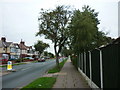
6
Houses with porches, south side, Centenary Road
Like a row of sentry boxes.
Image: © Christine Johnstone
Taken: 9 Jul 2014
0.09 miles
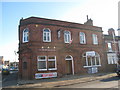
7
![Goole Joint Cadet Centre, from the rear [west]](https://s1.geograph.org.uk/geophotos/04/06/33/4063321_dca5dd5d_120x120.jpg)
Goole Joint Cadet Centre, from the rear [west]
Part of a range of buildings, built as a Drill Hall. The main entrance is behind the Catholic Church in Pasture Road.
Image: © Christine Johnstone
Taken: 9 Jul 2014
0.10 miles
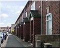
8
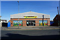
The Buchanan, Wetherill Street, Goole
Image: © Jonathan Thacker
Taken: 8 Jan 2011
0.10 miles
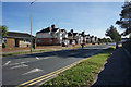
10
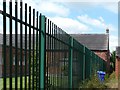
Goole Joint Cadet Centre, from the east
Part of a range of buildings, built as a Drill Hall. The security fence surrounds church grounds in Pasture Road.
Image: © Christine Johnstone
Taken: 9 Jul 2014
0.11 miles