IMAGES TAKEN NEAR TO
Manor Road, GOOLE, DN14 5SA
Introduction
This page details the photographs taken nearby to Manor Road, DN14 5SA by members of the Geograph project.
The Geograph project started in 2005 with the aim of publishing, organising and preserving representative images for every square kilometre of Great Britain, Ireland and the Isle of Man.

There are currently over 7.5m images from over14,400 individuals and you can help contribute to the project by visiting https://www.geograph.org.uk
Image Map
Images are licensed for reuse under creativecommons.org/licenses/by-sa/2.0
Notes
- Clicking on the map will re-center to the selected point.
- The higher the marker number, the further away the image location is from the centre of the postcode.
Image Listing (56 Images Found)
Images are licensed for reuse under creativecommons.org/licenses/by-sa/2.0
Image
Details
Distance
1
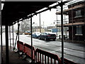
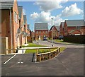
Upgrading Percy Street Park
Picture taken 05/02/09 showing work being undertaken to upgrade the kids park on Percy Street. All the houses in the street were also undergoing work to 'Tidy up' the street (and area) as part of an EC initiative.
Image: © John Bell
Taken: 5 Feb 2009
0.04 miles
2
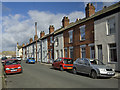
Heber Street, Old Goole
One of three parallel streets of terraced housing between Cottingham Street and Percy Street. Like many of the houses in Old Goole, they have recently benefited from an East Riding of Yorkshire Council scheme of free repairs and renovation: http://www.eastriding.gov.uk/cs/housing-and-public-protection/housing-services/private-sector-housing/asbestos/advance-goole/
Image: © Paul Harrop
Taken: 28 Mar 2010
0.08 miles

6
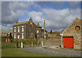
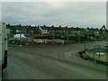
Bridge Farm, Old Goole
Farmhouse sitting in a narrow strip between the Dutch River, fertiliser works and rows of terraced housing. The barns on the right look to have been recently and attractively renovated.
Image: © Paul Harrop
Taken: 28 Mar 2010
0.14 miles
8
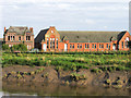
Old Goole Board School
Old Goole Board School in Old Goole before its demolition.
The view is across the 'Dutch River', which is tidal and carries the massively diverted waters of the River Don, - hence the muddy slope.
(Thanks to Patsy Kearsley for providing me with the correct name for this school.)
Image: © Trevor Littlewood
Taken: 15 Aug 2004
0.17 miles
9
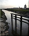
Goole port (5) ? Dutch River
The Dutch River is an artificial waterway. The boat hoist can be seen to the right.
This is one of a series of photos of the port. There is no meaningful sequence so they can be seen in any order, but click here http://www.geograph.org.uk/photo/1485827 for the next one I submitted.
Image: © Stephen Richards
Taken: Unknown
0.17 miles
10
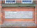
Goole, Old Goole Board School Foundation Stone
The writing that has been obliterated, reads Old Goole
Image: © Gordon Kneale Brooke
Taken: 23 Apr 2006
0.17 miles