IMAGES TAKEN NEAR TO
Roseacres, GOOLE, DN14 5PP
Introduction
This page details the photographs taken nearby to Roseacres, DN14 5PP by members of the Geograph project.
The Geograph project started in 2005 with the aim of publishing, organising and preserving representative images for every square kilometre of Great Britain, Ireland and the Isle of Man.

There are currently over 7.5m images from over14,400 individuals and you can help contribute to the project by visiting https://www.geograph.org.uk
Image Map (Loading...)


Getting Data...Please wait
Leaflet Map data © OpenStreetMap
Images are licensed for reuse under creativecommons.org/licenses/by-sa/2.0
Notes
- Clicking on the map will re-center to the selected point.
- The higher the marker number, the further away the image location is from the centre of the postcode.
Image Listing (30 Images Found)
Images are licensed for reuse under creativecommons.org/licenses/by-sa/2.0
Image
Details
Distance
2
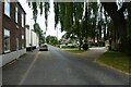
Willow on Hook High Street
Looking along Hook High Street which leads to various residential streets.
Image: © DS Pugh
Taken: 17 Jun 2023
0.06 miles
3
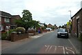
High Street, Hook
Looking along Hook High Street. The village of Hook is located along the banks of the River Ouse.
Image: © DS Pugh
Taken: 17 Jun 2023
0.08 miles
4
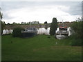
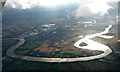
Resting at Hook
Whilst at low tide these boats seem far from the water, at high tide they are almost afloat.
Image: © Jonathan Thacker
Taken: 5 May 2012
0.11 miles
5
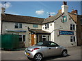
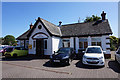
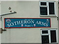
The Sotheron Arms, Hook
A freehouse selling some Sam Smith's beers
Image: © Ian S
Taken: 4 May 2011
0.13 miles
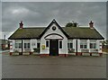
6
The Sotheron Arms, Hook
A freehouse selling Sam Smith's beers.
Image: © Ian S
Taken: 4 May 2011
0.13 miles