IMAGES TAKEN NEAR TO
Balk Lane, GOOLE, DN14 0GU
Introduction
This page details the photographs taken nearby to Balk Lane, DN14 0GU by members of the Geograph project.
The Geograph project started in 2005 with the aim of publishing, organising and preserving representative images for every square kilometre of Great Britain, Ireland and the Isle of Man.

There are currently over 7.5m images from over14,400 individuals and you can help contribute to the project by visiting https://www.geograph.org.uk
Image Map (7 Images)


Getting Data...Please wait
Leaflet Map data © OpenStreetMap
Images are licensed for reuse under creativecommons.org/licenses/by-sa/2.0
Notes
- Clicking on the map will re-center to the selected point.
- The higher the marker number, the further away the image location is from the centre of the postcode.
Image Listing (7 Images Found)
Images are licensed for reuse under creativecommons.org/licenses/by-sa/2.0
Image
Details
Distance
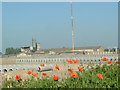
1
Balk Lane, Pollington
Taken from the Eastern end of Heck and Pollington Lane.
Image: © Ian S
Taken: 3 Nov 2010
0.12 miles
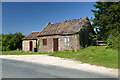
4
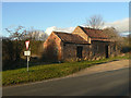
Old building on Pinfold Lane
Marked on old OS maps as a smithy.
Image: © Alan Murray-Rust
Taken: 27 Dec 2011
0.21 miles
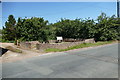
5
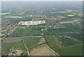
Aire and Caulder Canal and building site at Pollington: aerial 2022
Image: © Simon Tomson
Taken: 17 Apr 2022
0.21 miles