IMAGES TAKEN NEAR TO
Balne Moor Road, GOOLE, DN14 0EU
Introduction
This page details the photographs taken nearby to Balne Moor Road, DN14 0EU by members of the Geograph project.
The Geograph project started in 2005 with the aim of publishing, organising and preserving representative images for every square kilometre of Great Britain, Ireland and the Isle of Man.

There are currently over 7.5m images from over14,400 individuals and you can help contribute to the project by visiting https://www.geograph.org.uk
Image Map
Images are licensed for reuse under creativecommons.org/licenses/by-sa/2.0
Notes
- Clicking on the map will re-center to the selected point.
- The higher the marker number, the further away the image location is from the centre of the postcode.
Image Listing (26 Images Found)
Images are licensed for reuse under creativecommons.org/licenses/by-sa/2.0
Image
Details
Distance
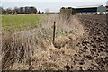
2
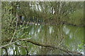
The pond at Brick Pond Farm off Balne Moor Lane
Image: © Ian S
Taken: 9 Apr 2014
0.05 miles
5
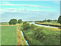
Pollington, Aire and Calder Canal
Image: © Gordon Kneale Brooke
Taken: 8 Jul 2006
0.13 miles
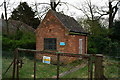
9
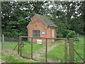
Building belonging to Yorkshire Water
Is it still used?
Image: © Jonathan Thacker
Taken: 1 Aug 2014
0.17 miles