IMAGES TAKEN NEAR TO
Stonecliff Walk, DONCASTER, DN12 4UN
Introduction
This page details the photographs taken nearby to Stonecliff Walk, DN12 4UN by members of the Geograph project.
The Geograph project started in 2005 with the aim of publishing, organising and preserving representative images for every square kilometre of Great Britain, Ireland and the Isle of Man.

There are currently over 7.5m images from over14,400 individuals and you can help contribute to the project by visiting https://www.geograph.org.uk
Image Map
Images are licensed for reuse under creativecommons.org/licenses/by-sa/2.0
Notes
- Clicking on the map will re-center to the selected point.
- The higher the marker number, the further away the image location is from the centre of the postcode.
Image Listing (20 Images Found)
Images are licensed for reuse under creativecommons.org/licenses/by-sa/2.0
Image
Details
Distance
5
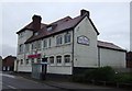
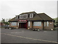
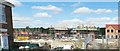
The Balti Palace, Conisbrough
On Doncaster Road.
Image: © JThomas
Taken: 9 Feb 2013
0.10 miles
6
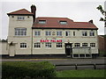
The Balti Palace restaurant
The former Denaby Main Hotel
Image: © Ian S
Taken: 19 May 2012
0.11 miles
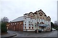
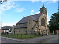
10
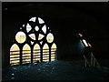
Hepworth Hall
The upper level of the chapel that was built in 1891. It was most recently used as a photographer's studio until a fire. Soon to be flats.
Image: © stephen samson
Taken: 16 Nov 2008
0.16 miles