IMAGES TAKEN NEAR TO
Knaresborough Road, DONCASTER, DN12 3PT
Introduction
This page details the photographs taken nearby to Knaresborough Road, DN12 3PT by members of the Geograph project.
The Geograph project started in 2005 with the aim of publishing, organising and preserving representative images for every square kilometre of Great Britain, Ireland and the Isle of Man.

There are currently over 7.5m images from over14,400 individuals and you can help contribute to the project by visiting https://www.geograph.org.uk
Image Map (Loading...)


Getting Data...Please wait
Leaflet Map data © OpenStreetMap
Images are licensed for reuse under creativecommons.org/licenses/by-sa/2.0
Notes
- Clicking on the map will re-center to the selected point.
- The higher the marker number, the further away the image location is from the centre of the postcode.
Image Listing (9 Images Found)
Images are licensed for reuse under creativecommons.org/licenses/by-sa/2.0
Image
Details
Distance
2
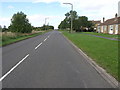
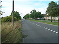
Hill Top Road
The appropriately named Hill Top Road on the edge of Conisbrough.
Image: © Michael Patterson
Taken: 6 Oct 2006
0.07 miles
7
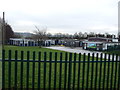
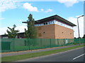
New School
Part of rebuilding Doncaster schools by Kier Northern.
Image: © Steve Fareham
Taken: 14 May 2008
0.18 miles
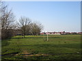
8
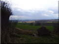
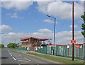
Rocks blocking field entrance.
Good views down to Hooten roberts and Rotherham.
Image: © steven ruffles
Taken: 1 Apr 2010
0.20 miles