IMAGES TAKEN NEAR TO
The Oval, DONCASTER, DN12 3JB
Introduction
This page details the photographs taken nearby to The Oval, DN12 3JB by members of the Geograph project.
The Geograph project started in 2005 with the aim of publishing, organising and preserving representative images for every square kilometre of Great Britain, Ireland and the Isle of Man.

There are currently over 7.5m images from over14,400 individuals and you can help contribute to the project by visiting https://www.geograph.org.uk
Image Map
Images are licensed for reuse under creativecommons.org/licenses/by-sa/2.0
Notes
- Clicking on the map will re-center to the selected point.
- The higher the marker number, the further away the image location is from the centre of the postcode.
Image Listing (195 Images Found)
Images are licensed for reuse under creativecommons.org/licenses/by-sa/2.0
Image
Details
Distance
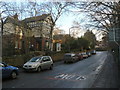
2
Top of Station Road
Looking downhill towards Mexborough. The road was former used by the trolleybuses of the Mexborough and Swinton Traction Co. The postbox has ref. No. DN12 295.
Image: © Alan Murray-Rust
Taken: 10 Feb 2010
0.06 miles
4
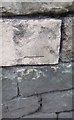
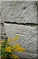
Ordnance Survey Cut Mark
This OS cut mark can be found on the NE side of Station Road. It marks a point 49.109m above mean sea level.
Image: © Adrian Dust
Taken: 29 May 2016
0.08 miles
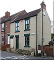
5
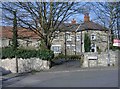
On Station Road
This fine Victorian house is now a dental practice. The road was former used by the trolleybuses of the Mexborough and Swinton Traction Co.
Image: © Alan Murray-Rust
Taken: 10 Feb 2010
0.08 miles
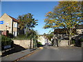
6
Top of Station Road
It is astonishing to find that the very narrow road ahead was once served, in both directions, by the Mexborough and Swinton Traction Company's main trolleybus route into Conisbrough.
Image: © Alan Murray-Rust
Taken: 10 Feb 2010
0.08 miles
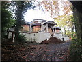
7
Conisbrough - house at bottom of Dale View
Image: © Dave Bevis
Taken: 5 Apr 2014
0.09 miles
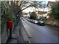
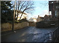
8
Dale View, looking towards Station Road
Image: © Basher Eyre
Taken: 24 Oct 2018
0.10 miles
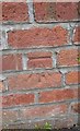
9
Ordnance Survey Cut Mark
This OS cut mark can be found on the front of the old vicarage. It marks a point 49.109m above mean sea level.
Image: © Adrian Dust
Taken: 29 May 2016
0.11 miles
10
Ordnance Survey Cut Mark
This OS cut mark can be found on the school wall, Station Road. It marks a point 28.221m above mean sea level.
Image: © Adrian Dust
Taken: 29 May 2016
0.13 miles