IMAGES TAKEN NEAR TO
Brook Square, DONCASTER, DN12 3HB
Introduction
This page details the photographs taken nearby to Brook Square, DN12 3HB by members of the Geograph project.
The Geograph project started in 2005 with the aim of publishing, organising and preserving representative images for every square kilometre of Great Britain, Ireland and the Isle of Man.

There are currently over 7.5m images from over14,400 individuals and you can help contribute to the project by visiting https://www.geograph.org.uk
Image Map
Images are licensed for reuse under creativecommons.org/licenses/by-sa/2.0
Notes
- Clicking on the map will re-center to the selected point.
- The higher the marker number, the further away the image location is from the centre of the postcode.
Image Listing (128 Images Found)
Images are licensed for reuse under creativecommons.org/licenses/by-sa/2.0
Image
Details
Distance
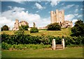
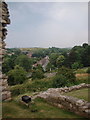
1
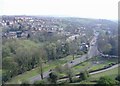
Conisbrough
The view south, from the castle keep.
Image: © Roger Cornfoot
Taken: 14 Apr 2007
0.02 miles
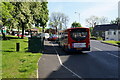
3
P Fuels in Conisbrough and Drive down the cost of motoring
Junction with Doncaster Road.
Image: © Steve Fareham
Taken: 23 Feb 2010
0.04 miles
5
Conisbrough Castle
Conisbrough Castle is an impressive stone motte and bailey type castle. The motte is a natural mound heavily fortified.
Image: © Paul Allison
Taken: Unknown
0.07 miles
6
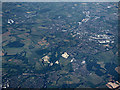
Quarries near Conisbrough from the air
Conisbrough isin the foreground. Cadeby quarry is on the left, Warmsworth quarry in the centre, Holme Hall quarry in the lower right corner.
Image: © Thomas Nugent
Taken: 6 Jul 2020
0.07 miles
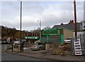
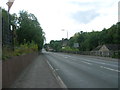
7
A6023 and Conisbrough
View of the A6023 as it passes Conisbrough Castle.
Image: © Darren Haddock
Taken: 9 Aug 2003
0.07 miles
8
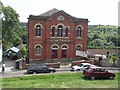
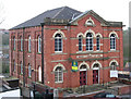
Wesley Chapel
This building of worship was built in 1876, and is now Conisbrough Methodist Church.
Image: © mike smith
Taken: 5 Aug 2007
0.08 miles
9
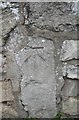
Ordnance Survey Cut Mark
This OS cut mark can be found on the wall, north side of New Hill. It marks a point 47.512m above mean sea level.
Image: © Adrian Dust
Taken: 29 May 2016
0.08 miles
10
Conisbrough - Wesley Chapel
For an alternative view, please see Image
Image: © Dave Bevis
Taken: 5 Apr 2014
0.09 miles