IMAGES TAKEN NEAR TO
Brook Road, DONCASTER, DN12 3AQ
Introduction
This page details the photographs taken nearby to Brook Road, DN12 3AQ by members of the Geograph project.
The Geograph project started in 2005 with the aim of publishing, organising and preserving representative images for every square kilometre of Great Britain, Ireland and the Isle of Man.

There are currently over 7.5m images from over14,400 individuals and you can help contribute to the project by visiting https://www.geograph.org.uk
Image Map
Images are licensed for reuse under creativecommons.org/licenses/by-sa/2.0
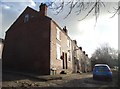
Notes
- Clicking on the map will re-center to the selected point.
- The higher the marker number, the further away the image location is from the centre of the postcode.
Image Listing (109 Images Found)
Images are licensed for reuse under creativecommons.org/licenses/by-sa/2.0
Image
Details
Distance
3
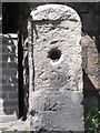
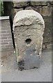
Old Milestone by the A630, Doncaster Road, Conisbrough parish
Stone post (plate lost) by the A630, in parish of CONISBROUGH (DONCASTER District), Doncaster Road, Conisbrough, in pavement east of traffic lights, on North side of road. Erected by the Tinsley & Doncaster turnpike trust in the 18th/19th century.
Inscription once read:-
(DONCASTER)
(4)
(ROTHERAM)
(7)
(SHEFFIELD)
(13)
Carved inverted benchmark on lower face.
Milestone Society National ID: YS_DNSF05.
Image: © C Minto
Taken: 1 Jul 1992
0.11 miles
4
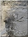
Ordnance Survey Cut Mark
This inverted OS cut mark can be found on the mile stone, north side of Doncaster Road. It marks a point 48.037m above mean sea level. http://www.geograph.org.uk/photo/4970634
Image: © Adrian Dust
Taken: 29 May 2016
0.11 miles
5
Damaged Milestone
There is an inverted Ordnance Survey cut mark on the milestone. http://www.geograph.org.uk/photo/4970625
Image: © Adrian Dust
Taken: 29 May 2016
0.11 miles
6
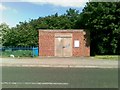
Electricity sub station, Windmill Avenue
Image: © Alex McGregor
Taken: 25 Jun 2012
0.13 miles
7
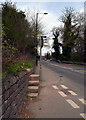
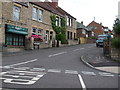
Low Road (A6023), Conisbrough
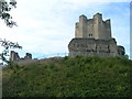
The steps on the left lead to a path going to Conisbrough Castle.
Image: © habiloid
Taken: 8 Apr 2021
0.13 miles
8
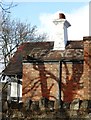
Shadows on "The Castle Inn", Conisbrough
A once popular public house, "The Castle" is no more. Sadly, these former licensed premises have been converted to residential dwellings.
Image: © Neil Theasby
Taken: 26 Feb 2015
0.13 miles
10
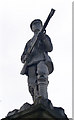
Soldier on top of war memorial, Conisbrough
Image: © Steve Fareham
Taken: 12 Aug 2007
0.14 miles