IMAGES TAKEN NEAR TO
Ash Grove, DONCASTER, DN12 2HH
Introduction
This page details the photographs taken nearby to Ash Grove, DN12 2HH by members of the Geograph project.
The Geograph project started in 2005 with the aim of publishing, organising and preserving representative images for every square kilometre of Great Britain, Ireland and the Isle of Man.

There are currently over 7.5m images from over14,400 individuals and you can help contribute to the project by visiting https://www.geograph.org.uk
Image Map
Images are licensed for reuse under creativecommons.org/licenses/by-sa/2.0
Notes
- Clicking on the map will re-center to the selected point.
- The higher the marker number, the further away the image location is from the centre of the postcode.
Image Listing (16 Images Found)
Images are licensed for reuse under creativecommons.org/licenses/by-sa/2.0
Image
Details
Distance
1
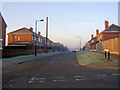
Ellershaw Lane from Lewes Road Conisbrough
Image: © Steve Fareham
Taken: 12 Feb 2008
0.08 miles
2
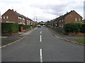
Laburnum Grove
The streets in this part of Conisbrough take their names from trees.
Image: © Michael Patterson
Taken: 6 Oct 2006
0.16 miles
3
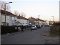
Maple Grove
The streets in this part of Conisbrough are mostly named after trees.
Image: © Jonathan Thacker
Taken: 17 Mar 2016
0.16 miles
6
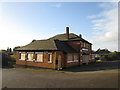
Chillis2 no more
Former pub, now a former restaurant, on Park Road Conisbrough
Image: © John Slater
Taken: 12 Nov 2013
0.17 miles
7
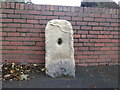
Milestone with benchmark, Sheffield Road Conisbrough
Image: © John Slater
Taken: 12 Nov 2013
0.18 miles
8
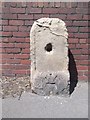
Old Milestone by the A630, Sheffield Road, Conisbrough
Stone post (plate lost) by the A630, in parish of Conisbrough (Doncaster District), Sheffield Road, West end of Conisbrough, in pavement, on North side of road. Erected by the Tinsley & Doncaster turnpike trust in the 18th/19th century.
Inscription once read:-
(Doncaster
(6)
(Rotherham)
(6)
Carved benchmark on lower front, upside down.
Milestone Society National ID: YS_DNSF06
Image: © C Minto
Taken: 1 Jul 1992
0.18 miles

10
A630 Sheffield Road at Conisbrough boundary
Image: © Colin Pyle
Taken: 7 Apr 2019
0.20 miles