IMAGES TAKEN NEAR TO
Drake Head Lane, DONCASTER, DN12 2AB
Introduction
This page details the photographs taken nearby to Drake Head Lane, DN12 2AB by members of the Geograph project.
The Geograph project started in 2005 with the aim of publishing, organising and preserving representative images for every square kilometre of Great Britain, Ireland and the Isle of Man.

There are currently over 7.5m images from over14,400 individuals and you can help contribute to the project by visiting https://www.geograph.org.uk
Image Map
Images are licensed for reuse under creativecommons.org/licenses/by-sa/2.0
Notes
- Clicking on the map will re-center to the selected point.
- The higher the marker number, the further away the image location is from the centre of the postcode.
Image Listing (6 Images Found)
Images are licensed for reuse under creativecommons.org/licenses/by-sa/2.0
Image
Details
Distance
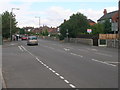
5
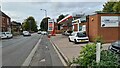
Filling station on A630
Recording what is a low price in these parts in October 2022, with every pump in service
Image: © Chris Morgan
Taken: 19 Oct 2022
0.14 miles
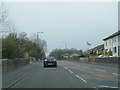
6
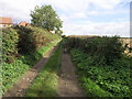
Drake Head Lane
Drake Head Lane runs from Conisbrough to New Edlington.
Image: © Michael Patterson
Taken: 6 Oct 2006
0.17 miles