IMAGES TAKEN NEAR TO
Sunningdale Drive, DONCASTER, DN12 1QR
Introduction
This page details the photographs taken nearby to Sunningdale Drive, DN12 1QR by members of the Geograph project.
The Geograph project started in 2005 with the aim of publishing, organising and preserving representative images for every square kilometre of Great Britain, Ireland and the Isle of Man.

There are currently over 7.5m images from over14,400 individuals and you can help contribute to the project by visiting https://www.geograph.org.uk
Image Map (Loading...)


Getting Data...Please wait
Leaflet Map data © OpenStreetMap
Images are licensed for reuse under creativecommons.org/licenses/by-sa/2.0
Notes
- Clicking on the map will re-center to the selected point.
- The higher the marker number, the further away the image location is from the centre of the postcode.
Image Listing (4 Images Found)
Images are licensed for reuse under creativecommons.org/licenses/by-sa/2.0
Image
Details
Distance
2
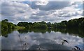
Martinwell lake.
Otherwise known as the Brickyards pond.
Image: © steven ruffles
Taken: 3 Jun 2018
0.19 miles
3
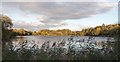
Martinwell Lake Edlington
This former clay quarry and brickworks at Edlington has now been transformed into a beautiful lake for the benefit of the local community and visitors. It is now popular for walking and fishing.
Image: © Tim Gummer
Taken: 23 Oct 2013
0.21 miles
4
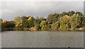
Martinwell Lake Edlington
This former clay quarry and brickworks has been transformed into a beautiful lake for the enjoyment of the local community and visitors. It is popular for walking and fishing
Image: © Tim Gummer
Taken: 27 Oct 2013
0.23 miles