IMAGES TAKEN NEAR TO
Broomhouse Lane, DONCASTER, DN12 1ES
Introduction
This page details the photographs taken nearby to Broomhouse Lane, DN12 1ES by members of the Geograph project.
The Geograph project started in 2005 with the aim of publishing, organising and preserving representative images for every square kilometre of Great Britain, Ireland and the Isle of Man.

There are currently over 7.5m images from over14,400 individuals and you can help contribute to the project by visiting https://www.geograph.org.uk
Image Map
Images are licensed for reuse under creativecommons.org/licenses/by-sa/2.0
Notes
- Clicking on the map will re-center to the selected point.
- The higher the marker number, the further away the image location is from the centre of the postcode.
Image Listing (5 Images Found)
Images are licensed for reuse under creativecommons.org/licenses/by-sa/2.0
Image
Details
Distance
1

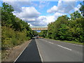
Trailer park
Empty trailers for the plastics-moulding factory on the opposite side of the main road are parked on land which was recently occupied by substantial, but redundant, stone-built barns. I am very disappointed that I did not find time to image them, rather than their successors.
Image: © Jonathan Wilkins
Taken: 28 Oct 2011
0.08 miles
2
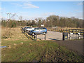
Pit Wood car park
The erstwhile tip of Yorkshire Main colliery has been landscaped and planted as a country park - and is now known as Edlington Pit Wood. A small car park caters for visitors.
Image: © Jonathan Wilkins
Taken: 31 Mar 2013
0.21 miles
3
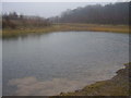
Pond on old pit site.
Great for cleaning the dog after a walk in muddy Edlington woods.
Image: © steven ruffles
Taken: 25 Feb 2010
0.23 miles
4
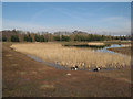
Reed bed and pond
Drainage from the old tip site is led to this pond near to the car park, the reed beds providing a good water-treatment capability.
Image: © Jonathan Wilkins
Taken: 31 Mar 2013
0.23 miles