IMAGES TAKEN NEAR TO
Gordon Road Flats, DONCASTER, DN12 1AG
Introduction
This page details the photographs taken nearby to Gordon Road Flats, DN12 1AG by members of the Geograph project.
The Geograph project started in 2005 with the aim of publishing, organising and preserving representative images for every square kilometre of Great Britain, Ireland and the Isle of Man.

There are currently over 7.5m images from over14,400 individuals and you can help contribute to the project by visiting https://www.geograph.org.uk
Image Map (Loading...)


Getting Data...Please wait
Leaflet Map data © OpenStreetMap
Images are licensed for reuse under creativecommons.org/licenses/by-sa/2.0
Notes
- Clicking on the map will re-center to the selected point.
- The higher the marker number, the further away the image location is from the centre of the postcode.
Image Listing (11 Images Found)
Images are licensed for reuse under creativecommons.org/licenses/by-sa/2.0
Image
Details
Distance
1
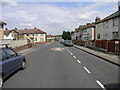
20 Red Bump
This lonely looking speed bump reminds drivers that the limit is 20mph. The housing was originally built to house the families and miners of the nearby coal mine.
Image: © Michael Patterson
Taken: 7 Jul 2006
0.02 miles
3
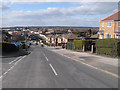
Edlington Lane, Edlington
Viewed from outside the Royal British Legion.
Image: © Mark Anderson
Taken: 23 Mar 2016
0.12 miles
4
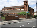
Red Brick Church
Sitting on the southern edge of this square both the church and the road are dedicated to St John. The blue sign points to a recreation ground.
Image: © Michael Patterson
Taken: 7 Jul 2006
0.14 miles
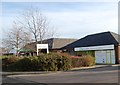
5
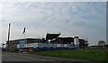
Building the new Edlington Centre
Construction of steel framed building on Thompson Avenue by Morgan Ashurst.
Image: © Steve Fareham
Taken: 11 May 2008
0.17 miles
6
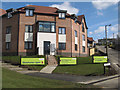
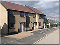
New housing, Stubbins Hill
A view of the new apartment building that stands at the corner of Stubbins Hill and Broomhouse Lane. Part of the Yew Gardens re-development of an earlier housing estate that had fallen on hard times.
Image: © Jonathan Wilkins
Taken: 31 Mar 2013
0.20 miles
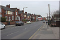
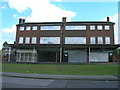
7
Junction of Broomhouse Lane and Stubbins Hill in New Edlington
A housing development can be seen on the left, and The Grainger centre is partially visible on the right.
Image: © Jonathan Clitheroe
Taken: 10 Jun 2017
0.21 miles
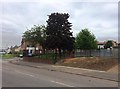
9
Bernard Road
Looking down the hill towards Broomhouse Lane, and across Edlington to the Don Valley and distant tree-covered hills.
Image: © Jonathan Wilkins
Taken: 31 Mar 2013
0.24 miles
10
New housing, Granby Road
Newly-completed houses alongside others still in build. The whole development is known as Yew Gardens, but whether the old road names will be retained is unknown. Geography is a bit hazy here at present!
Image: © Jonathan Wilkins
Taken: 31 Mar 2013
0.24 miles