IMAGES TAKEN NEAR TO
Sunnyview Park, Grange Lane, DONCASTER, DN11 9DS
Introduction
This page details the photographs taken nearby to Sunnyview Park, Grange Lane, DN11 9DS by members of the Geograph project.
The Geograph project started in 2005 with the aim of publishing, organising and preserving representative images for every square kilometre of Great Britain, Ireland and the Isle of Man.

There are currently over 7.5m images from over14,400 individuals and you can help contribute to the project by visiting https://www.geograph.org.uk
Image Map
Images are licensed for reuse under creativecommons.org/licenses/by-sa/2.0
Notes
- Clicking on the map will re-center to the selected point.
- The higher the marker number, the further away the image location is from the centre of the postcode.
Image Listing (22 Images Found)
Images are licensed for reuse under creativecommons.org/licenses/by-sa/2.0
Image
Details
Distance
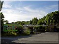
1
View towards Alverley Grange Caravan Park
Image: © Jonathan Thacker
Taken: 22 Oct 2015
0.05 miles
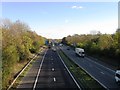
3
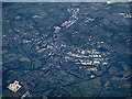
Doncaster from the air
Junction 35 on the A1(M) motorway where it crosses the M18 motorway (Junction 2) is in the lower right corner.
Image: © Thomas Nugent
Taken: 6 Jul 2020
0.07 miles
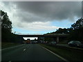
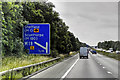
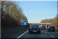
4
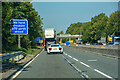
Warmsworth : A1(M)
Looking along the A1(M) heading northbound.
Image: © Lewis Clarke
Taken: 21 Sep 2020
0.10 miles
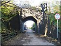
7
Entrance to Bridgeacre Nursery
On Bromhouse Lane.
Image: © Steve Fareham
Taken: 10 Jun 2008
0.11 miles
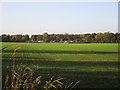
8
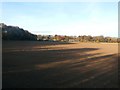
Ploughed Field and Long Shadows
Pictured on a fine and sunny November afternoon. The area beyond the field is a caravan site.
Image: © Jonathan Clitheroe
Taken: 2 Nov 2016
0.11 miles