IMAGES TAKEN NEAR TO
McConnel Crescent, DONCASTER, DN11 0YQ
Introduction
This page details the photographs taken nearby to McConnel Crescent, DN11 0YQ by members of the Geograph project.
The Geograph project started in 2005 with the aim of publishing, organising and preserving representative images for every square kilometre of Great Britain, Ireland and the Isle of Man.

There are currently over 7.5m images from over14,400 individuals and you can help contribute to the project by visiting https://www.geograph.org.uk
Image Map
Images are licensed for reuse under creativecommons.org/licenses/by-sa/2.0
Notes
- Clicking on the map will re-center to the selected point.
- The higher the marker number, the further away the image location is from the centre of the postcode.
Image Listing (15 Images Found)
Images are licensed for reuse under creativecommons.org/licenses/by-sa/2.0
Image
Details
Distance
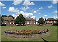
1
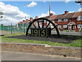
On King George's Road, Rossington
The erection of the Miners Wheel adjacent to the Parish Hall on McConnell Crescent has been successfully completed. The plaque showing the date 1913 relates to the year that most of the work was carried out sinking the shafts, and the plaque date 1915 relates to the year that the underground development works reached the coal seams. The positioning of the memorial garden is significant in the sense that the plot of land was probably the site of some of the huts that were occupied by the men who were employed to sink the shafts, as well as being surrounded by some of the first houses that were built by the Colliery Company.
Image: © Neil Theasby
Taken: 9 Aug 2014
0.06 miles
3
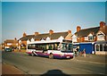
Bus on King Avenue, New Rossington
First South Yorkshire 40524, a Dennis/Plaxton Super Pointer Dart, loads outside the shops on King Avenue while working route 55 to Doncaster.
Image: © Richard Vince
Taken: 16 Feb 2008
0.08 miles
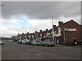
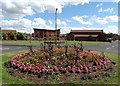
4
King Avenue shops, New Rossington
Opposite Nelson Road.
Image: © Steve Fareham
Taken: 14 Mar 2009
0.08 miles
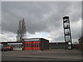
9
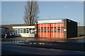
Rossington fire station
Rossington fire station, West End Lane, Rossington, South Yorkshire
Image: © Kevin Hale
Taken: 5 Dec 2009
0.16 miles
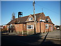
10
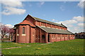
Church of St.Luke the Evangelist, New Rossington
Parish church for the colliery village of New Rossington, built c1925.
Image: © Richard Croft
Taken: 28 Apr 2006
0.16 miles