IMAGES TAKEN NEAR TO
Newington Road, DONCASTER, DN10 6FD
Introduction
This page details the photographs taken nearby to Newington Road, DN10 6FD by members of the Geograph project.
The Geograph project started in 2005 with the aim of publishing, organising and preserving representative images for every square kilometre of Great Britain, Ireland and the Isle of Man.

There are currently over 7.5m images from over14,400 individuals and you can help contribute to the project by visiting https://www.geograph.org.uk
Image Map (Loading...)


Getting Data...Please wait
Leaflet Map data © OpenStreetMap
Images are licensed for reuse under creativecommons.org/licenses/by-sa/2.0
Notes
- Clicking on the map will re-center to the selected point.
- The higher the marker number, the further away the image location is from the centre of the postcode.
Image Listing (33 Images Found)
Images are licensed for reuse under creativecommons.org/licenses/by-sa/2.0
Image
Details
Distance

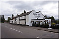
2
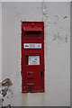
Victorian postbox at the Ship Inn, Newington Road
Image: © Ian S
Taken: 29 Aug 2020
0.04 miles
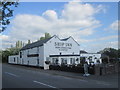
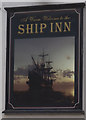
5
The Ship Inn, Newington
The pub is close to the River Idle which is navigable to Bawtry and was an important river port up to the 16th century.
Image: © Graham Hogg
Taken: 12 Dec 2016
0.04 miles

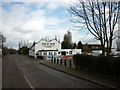
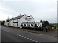
10
Ship Inn, Newington
The name may reflect the fact that the adjacent River Idle was navigable to Bawtry in the middle ages. It was doing a brisk trade in Sunday lunches on this day.
Image: © Alan Murray-Rust
Taken: 22 Jul 2007
0.05 miles