IMAGES TAKEN NEAR TO
Mill Lane, DONCASTER, DN10 6AQ
Introduction
This page details the photographs taken nearby to Mill Lane, DN10 6AQ by members of the Geograph project.
The Geograph project started in 2005 with the aim of publishing, organising and preserving representative images for every square kilometre of Great Britain, Ireland and the Isle of Man.

There are currently over 7.5m images from over14,400 individuals and you can help contribute to the project by visiting https://www.geograph.org.uk
Image Map (Loading...)


Getting Data...Please wait
Leaflet Map data © OpenStreetMap
Images are licensed for reuse under creativecommons.org/licenses/by-sa/2.0
Notes
- Clicking on the map will re-center to the selected point.
- The higher the marker number, the further away the image location is from the centre of the postcode.
Image Listing (69 Images Found)
Images are licensed for reuse under creativecommons.org/licenses/by-sa/2.0
Image
Details
Distance
1
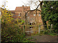
Monk's Mill, Scrooby
This is the rear of the mill, seen across the former tailrace. The mill buildings are an amalgam of sections, dating back in part to the 17th century. The mill appears to have had three wheels at one stage, making use of the flow of the River Ryton, but there is now only a trickle through the pond. Listed Grade II.
Image: © Alan Murray-Rust
Taken: 24 Nov 2014
0.00 miles
2
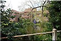
Monk's Mill
A 17th century converted water mill, grade II listed, which stands on the River Ryton
Image: © Graham Hogg
Taken: 11 Aug 2015
0.01 miles

4
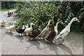
Getting the ducks in a row
Ducks of various hues returning in an orderly fashion to their pond at Monk's Mill Image
Image: © Graham Hogg
Taken: 11 Aug 2015
0.03 miles
5

Attention, Ecoles
What this French schools warning sign is doing at this location is a mystery, as it appears to be attached to an official post.
Image: © Alan Murray-Rust
Taken: 24 Nov 2014
0.03 miles
6
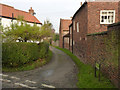
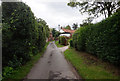
Dog Lane, Scrooby
There is an 'Unsuitable for motors' sign at the other end, but not at this.
Image: © Alan Murray-Rust
Taken: 24 Nov 2014
0.08 miles
8
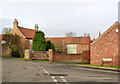
Homefield Farmhouse and barn range
The house is mid 18th century, the barn of 17th century origin, refaced in the 19th century. Both are Listed Grade II.
Image: © Alan Murray-Rust
Taken: 24 Nov 2014
0.08 miles
9
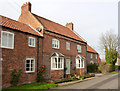
Mill House, Scrooby
Mid 18th century farmhouse with 19th century bay windows. Listed Grade II.
Image: © Alan Murray-Rust
Taken: 24 Nov 2014
0.10 miles
