IMAGES TAKEN NEAR TO
Drakeholes, DONCASTER, DN10 5DF
Introduction
This page details the photographs taken nearby to DN10 5DF by members of the Geograph project.
The Geograph project started in 2005 with the aim of publishing, organising and preserving representative images for every square kilometre of Great Britain, Ireland and the Isle of Man.

There are currently over 7.5m images from over14,400 individuals and you can help contribute to the project by visiting https://www.geograph.org.uk
Image Map
Images are licensed for reuse under creativecommons.org/licenses/by-sa/2.0
Notes
- Clicking on the map will re-center to the selected point.
- The higher the marker number, the further away the image location is from the centre of the postcode.
Image Listing (77 Images Found)
Images are licensed for reuse under creativecommons.org/licenses/by-sa/2.0
Image
Details
Distance
1
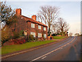
The Cottage, Drakeholes
There is a bench mark http://www.geograph.org.uk/photo/4260666 on the near corner of the cottage.
Image: © Alan Murray-Rust
Taken: 24 Nov 2014
0.01 miles
2
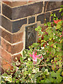
Flush bracket bench mark S9033
See http://www.geograph.org.uk/photo/4260671 for location.
Image: © Alan Murray-Rust
Taken: 24 Nov 2014
0.01 miles
4
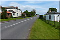
Drakeholes House
Looking north east along Gainsborough Road.
Image: © Alan Murray-Rust
Taken: 24 Nov 2014
0.04 miles
5
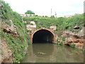
Bridge 73, Chesterfield Canal
Also known as Drakeholes Tunnel.
Image: © Mr Biz
Taken: 10 May 2009
0.04 miles
6
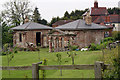
Wiseton Hall Gate Lodges, Drakeholes
Grade II Listed in 1977 the early 19th century Wiseton Hall Gatehouse Lodges and Gatepiers are currently undergoing restoration.
Image: © Jo and Steve Turner
Taken: 21 May 2012
0.04 miles
7
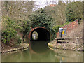
Drakeholes Tunnel
The 154 yard Drakeholes Tunnel on the Chesterfield Canal was built as can be seen, without a towpath meaning that narrowboats would need to be 'legged' through and the towing horses led over the top.
Image: © Trevor Littlewood
Taken: 12 Mar 2005
0.04 miles
8
Old Milestone by the B6045, Gainsborough Road, Drakesholes, Everton parish
Carved stone post by the B6045 (was A631), in parish of EVERTON (BASSETLAW District), Drakesholes, 200m Southwest of the A631 junction, opposite "Willow Hill", under hedge, near 'Giveway' sign, on South side of road. Gainsborough stone, erected by the Bawtry Bridge to Hainton turnpike trust in the 19th century.
Inscription once read:-
: (Bawtry / 4) : : (Gainsborough / 8) :
Milestone Society National ID: NT_BWGN04.
Image: © C Minto
Taken: 28 Jan 2005
0.05 miles
9
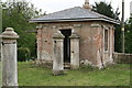
Wiseton Hall Gate Lodges, Drakeholes
Grade II Listed in 1977 the early 19th century Wiseton Hall Gatehouse Lodges and Gatepiers are currently undergoing restoration.
Image: © Jo and Steve Turner
Taken: 21 May 2012
0.05 miles
10
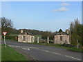
Gate lodges at Drakeholes
These were an entrance to Wiseton Hall, although most older OS maps do not show the existence of a driveway. They are listed as being early 19th century. They are in a very dilapidated state, but current satellite views show them as heavily overgrown, so some improvement has been made. Listed Grade II.
Postscript - August 2011
I have been contacted by the local Conservation Officer for Bassetlaw to say that the lodges are currently being restored, with the roofs already completed. It will be good to see how they look when the whole work is finished.
Image: © Alan Murray-Rust
Taken: 31 Mar 2011
0.05 miles