IMAGES TAKEN NEAR TO
Everton, DONCASTER, DN10 5BY
Introduction
This page details the photographs taken nearby to DN10 5BY by members of the Geograph project.
The Geograph project started in 2005 with the aim of publishing, organising and preserving representative images for every square kilometre of Great Britain, Ireland and the Isle of Man.

There are currently over 7.5m images from over14,400 individuals and you can help contribute to the project by visiting https://www.geograph.org.uk
Image Map
Images are licensed for reuse under creativecommons.org/licenses/by-sa/2.0
Notes
- Clicking on the map will re-center to the selected point.
- The higher the marker number, the further away the image location is from the centre of the postcode.
Image Listing (9 Images Found)
Images are licensed for reuse under creativecommons.org/licenses/by-sa/2.0
Image
Details
Distance
1
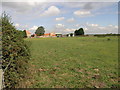
Claybank Farm
Despite its appearance on modern OS maps this farm appears to consist of recently built constructions.
Image: © Michael Patterson
Taken: 16 Aug 2006
0.01 miles
2
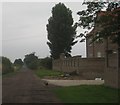
Claybank Lane
With Claybank Farm and its guardian, a very nervous terrier.
Image: © Jonathan Thacker
Taken: 31 Jul 2012
0.03 miles
3
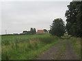
Everton Sluice Lane
Claybank Farm ahead.
Image: © Jonathan Thacker
Taken: 31 Jul 2012
0.04 miles
4
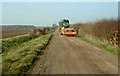
Repairing Clay Bank Lane
A vibrating roller heads North towards Everton Carr farm.
Image: © Steve Fareham
Taken: 21 Mar 2009
0.07 miles
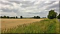
5
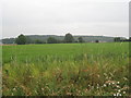
Wildflowers and Barrow Hills (2)
Taken from Everton Sluice Lane to the west of Claybank Farm.
Image: © Jonathan Thacker
Taken: 31 Jul 2012
0.12 miles
6

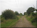
Barriers on Everton Sluice Lane
This section of Everton Sluice Lane is a bridleway but nearer Everton it becomes a public road.
Image: © Jonathan Thacker
Taken: 31 Jul 2012
0.17 miles
7
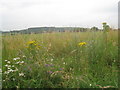
Wildflowers and Barrow Hills
Taken from Everton Sluice Lane.
Image: © Jonathan Thacker
Taken: 31 Jul 2012
0.20 miles
8
Harwell Sluice Lane
Looking towards Harwell.
Image: © Jonathan Thacker
Taken: 31 Jul 2012
0.21 miles