IMAGES TAKEN NEAR TO
Walkeringham, DONCASTER, DN10 4NB
Introduction
This page details the photographs taken nearby to DN10 4NB by members of the Geograph project.
The Geograph project started in 2005 with the aim of publishing, organising and preserving representative images for every square kilometre of Great Britain, Ireland and the Isle of Man.

There are currently over 7.5m images from over14,400 individuals and you can help contribute to the project by visiting https://www.geograph.org.uk
Image Map (19 Images)


Getting Data...Please wait
Leaflet Map data © OpenStreetMap
Images are licensed for reuse under creativecommons.org/licenses/by-sa/2.0
Notes
- Clicking on the map will re-center to the selected point.
- The higher the marker number, the further away the image location is from the centre of the postcode.
Image Listing (19 Images Found)
Images are licensed for reuse under creativecommons.org/licenses/by-sa/2.0
Image
Details
Distance
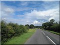
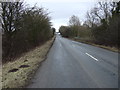
2
Entering Walkeringham
Heading north west on the B1403.
Image: © JThomas
Taken: 28 Feb 2015
0.07 miles
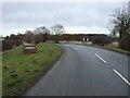
4

Misterton road
Looking towards Misterton on the B1403 road .
Image: © roger geach
Taken: 1 Jun 2009
0.13 miles
6
B1403, Walkeringham
Heading north east towards Misterton.
Image: © JThomas
Taken: 28 Feb 2015
0.18 miles
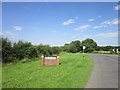
7
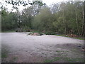
The car park, Walkeringham Nature Reserve
Much used by flytippers.
Image: © Jonathan Thacker
Taken: 23 Sep 2011
0.20 miles
8
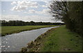
Chesterfield Canal near Walkeringham
The reach above Smith's bridge.
Image: © Alan Murray-Rust
Taken: 31 Mar 2011
0.21 miles
9

Chimney in the country
Looking across the field from the road is a former brick works chimney. Behind the hedge is the Chesterfield canal.
Image: © roger geach
Taken: 1 Jun 2009
0.21 miles
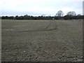
10
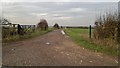
Track to Highfield Farm at the top of Wooden Beck Hill
A high point by the lowlands of the Trent valley as it approaches the Humber.
Image: © Chris Morgan
Taken: 24 Nov 2014
0.21 miles