IMAGES TAKEN NEAR TO
Canal Lane, DONCASTER, DN10 4ET
Introduction
This page details the photographs taken nearby to Canal Lane, DN10 4ET by members of the Geograph project.
The Geograph project started in 2005 with the aim of publishing, organising and preserving representative images for every square kilometre of Great Britain, Ireland and the Isle of Man.

There are currently over 7.5m images from over14,400 individuals and you can help contribute to the project by visiting https://www.geograph.org.uk
Image Map (Loading...)


Getting Data...Please wait
Leaflet Map data © OpenStreetMap
Images are licensed for reuse under creativecommons.org/licenses/by-sa/2.0
Notes
- Clicking on the map will re-center to the selected point.
- The higher the marker number, the further away the image location is from the centre of the postcode.
Image Listing (215 Images Found)
Images are licensed for reuse under creativecommons.org/licenses/by-sa/2.0
Image
Details
Distance
1
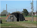
Nissen hut, West Stockwith
These are becoming ever rarer. This one is not in too healthy a state having clearly been subject to an incendiary attack.
Image: © Alan Murray-Rust
Taken: 31 Mar 2011
0.03 miles
2
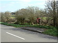
Chesterfield Terrace West postbox ref: DN10 341
Sited not too helpfully on the opposite side of the road to the houses and the footway, although this is also a bus stop. The label just below the posting slot announces that Saturday collections will no longer be made after 14 March 2011. E II R lampbox.
Image: © Alan Murray-Rust
Taken: 31 Mar 2011
0.04 miles
3
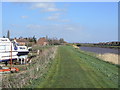
River Trent at the Stockwiths
To the left is a boatyard linked to the canal basin.
Image: © Alan Murray-Rust
Taken: 31 Mar 2011
0.06 miles
4
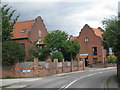
West Stockwith
Houses on Canal Lane at West Stockwith, two with Dutch gables - seen in places around the Isle of Axholme on 17th & 18th century houses built by Dutch settlers following the drainage of the marshland by Cornelius Vermuyden and fellow Dutch engineers
Image: © Richard Croft
Taken: 16 Feb 2012
0.07 miles
5
Dutch houses
Modern houses built with a nod to Dutch vernacular architecture as an acknowledgement that Cornelius Vermuyden was responsible for the drainage of much of the land in this area.
Image: © Jonathan Thacker
Taken: 14 Jun 2010
0.07 miles
6

West Stockwith
The opposite bank of the River Trent from East Stockwith
Image: © Richard Croft
Taken: 26 Nov 2008
0.08 miles
7
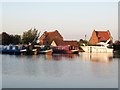
Stockwith Basin
Looking across the quieter, eastern side of the basin. There is a slipway on the far side.
Image: © Graham Horn
Taken: 23 Sep 2012
0.08 miles
8
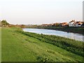
The Trent at the Stockwiths
A political and physical boundary between the two villages. East Stockwith is in Lincolnshire, West Stockwith in Nottinghamshire.
Image: © Christine Johnstone
Taken: 14 Oct 2011
0.09 miles
9
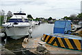
West Stockwith basin, Chesterfield Canal
The 'gin palace' looks a bit out of place alongside the narrowboats. But the Chesterfield Canal is wide all the way to Retford, and the River Trent is only a lock away.
Image: © Christine Johnstone
Taken: 14 Oct 2011
0.09 miles
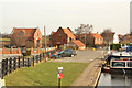
10
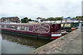
Stockwith Basin
There are two narrowboats for hire here, Maid Marion and, hidden behind her, Robin Hood. These offer a convenient way to explore the delightful Chesterfield Canal without having to negotiate the tricky, tidal River Trent. If you do wish to use the river, the lock down is adjacent to the brick building.
Image: © Graham Horn
Taken: 23 Sep 2012
0.10 miles